| |  |  | | Lake Pontchartrain Atlas: | | | | | | | | | | | | | | | | Environmental Status & Trends |  | | | | | | | | | | | | | | | | | | | | | | | | | | | | |  | | | | | | | | | | |  | Environmental Status and Trends - Status and Trends of the Lake Pontchartrain Basin Contributors: Penland, Maygarden, Beall The Plaquemines Wetland Area (PWA) encompasses 456,086 acres south of the MRGO and east of the Mississippi River (Figures 1 and 14). This area contains a variety of habitats including forested wetlands, fresh, intermediate, brackish and saline marshes that follow the salinity gradient from the Mississippi River to the fragmented salt marshes close to Breton Sound. Throughout history, these wetlands have received Mississippi River flood water and there has existed a dynamic relationship between the fresh river water and the saline water from Breton Sound. Prior to construction of flood control levees, natural crevasses distributed river water into the marsh. These occurred near Scarsdale and several natural waterways such as Oak River which is still an obvious landscape feature. In the 1920's, on the outside of the English Turn Bend in the River at Poydras, the Mississippi River levee was breached to allow the flooding River to overflow and relieve pressure on upstream levees in New Orleans. This was done in 1923 and then again during the great flood of 1927. Massive amounts of fresh water, sediment and nutrients flowed over the fields that, at that time, extended back into what is today marsh. Since colonial times, plantations and small farms existed along the Mississippi River natural levee, and the angular area of open water known as Big Mar was once agricultural land. The 1927 inundation flooded Big Mar, creating the large pond found today. It also deposited a thick layer of sediment and altered the landscape drastically, but during the decades that followed, further changes took place as saltwater intrusion and marsh erosion caused a landward shift of saline and brackish marsh habitats. Another reversal of conditions began in 1991 when the Caernarvon Freshwater Diversion Project, located close to the site of the 1927 levee break, became operational. Today there is again fresh marsh appearing in the vicinity of Big Mar and around Lake Lery and the saltwater interface has been shifted back towards Breton Sound. 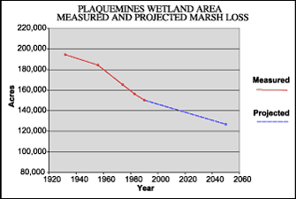 | | Figure 19. Measured marsh loss in the Plaquemines Wetland Area between 1932 and 1990 with projection to 2050 (Coast 2050, 1998). Refer to Table 5 for marsh loss comparison. | Between 1932 and 1990, a total of 23,270 acres of marsh were lost in this area (Figure 19). Without successful restoration, the PWA is projected to lose a further 26% by 2050. However, the Caernarvon Freshwater Diversion Project, which so far has succeeded in producing new marsh, should preserve 17,900 acres that would otherwise be lost (Table 5).A major cause of loss in this area has been storm-related, as hurricanes drove salty water into the fresh/intermediate northern portion. Meanwhile, a rapid subsidence rate of between 0.3 and 1.1 m (1.0 and 3.5 ft) per century, no longer offset by influxes of sediment-laden water from the River, has also been a major contributor to land loss. At the same time, human-induced changes, such as altered hydrology in the form of numerous canals, exacerbated the storm-related loss and caused greater tidal scour and saltwater intrusion. Even the massive amounts of sediment deposited in the 1920's could not prevent loss once the River levee was repaired. On the southern edges of the area, wind-related erosion has been, and continues to be, fairly extensive. Population trends for a selection of fish and wildlife species are shown in Tables 2, 3 and 4. Populations of many species of estuarine-dependent fishes have shown steady population trends, while others, particularly Gulf menhaden, white shrimp and blue crab are increasing in numbers. Freshwater species have tended to increase with the reduced salinity resulting from the Caernarvon Freshwater Diversion. The numbers of American oysters have greatly increased during the period in which the freshwater diversion has been operating. Populations of most types of birds that use the area are showing steady or increasing trends, as are alligators. « Previous | Next » |
