| |  |  | | Lake Pontchartrain Atlas: | | | | | | | | | | | | | | | | Environmental Status & Trends |  | | | | | | | | | | | | | | | | | | | | | | | | | | | | |  | | | | | | | | | | |  | Environmental Status and Trends - Status and Trends of the Lake Pontchartrain Basin Contributors: Penland, Maygarden, Beall 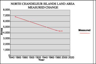 | | Figure 18: Measured change in the North Chandeleur Islands Land Area between 1855 and 1999 (Coast 2050, 1998). | The Chandeleur Islands Area (CIA) encompasses Chandeleur, Curlew, Grand Gosier and Breton Islands and the small islands and seagrass meadows to the west of them (Figures 1 and 14). The Chandeleur Islands form the easternmost boundary of the Mississippi River Deltaic Plain and the LPB. Between 1855 and 1999, the Chandeleur Islands decreased from 8,554 acres to 3,003 acres. Figure 18 illustrates the loss experienced by North Chandeleur Islands. They decreased in area from 1855 to 1996, at which time the area was 4,333 acres. Hurricanes are important events in the evolution and erosion of these and other barrier islands. After Hurricane Georges made landfall in the Chandeleur Islands in September 1998, the land area of the whole Chandeleur Islands Area decreased by 40% from 5,013 acres to 3,003 acres. Natural reworking of shifted sand by tidal and wave action will repair some of this damage, but the islands are generally decreasing in area and migrating to the west (see Shoreline Changes of the Northern Chandeleur Islands, Gulfside Shoreline Change Rates of the Northern Chandeleur Islands, Bayside Shoreline Change Rates of the Northern Chandeleur Islands, Shoreline Changes of the Southern Chandeleur Islands, Gulfside Shoreline Change Rates of the Southern Chandeleur Islands, and Bayside Shoreline Change Rates of the Southern Chandeleur Islands). The Breton National Wildlife Refuge covers northern Breton, Grand Gosier and Curlew Islands. The main Chandeleur Island north of Curlew Island is a designated Wilderness area, as is the southwestern end of Breton Island. The islands in this area support one of four brown pelican nesting colonies in Louisiana, as well as regionally significant seabird colonies. The extensive SAV beds behind the islands are important wintering areas for canvasback and red head ducks as well as a nursery area for recreationally and commercially important fish species. There are some infrequent occurrences of sea turtles nesting on the islands as well. Many of the bird species inhabiting the Chandeleur Islands, having been recently steady, are expected to decline in the near future. The brown pelican population is still increasing and is expected to continue to do so. « Previous | Next » |
