USGS Home - www.usgs.gov
Coastal and Marine Geology Program
Coastal & Marine Geology Program > Center for Coastal & Regional Marine Studies > Environmental Atlas of Lake Pontchartrain

Environmental Atlas of the Lake Pontchartrain Basin

Lake Pontchartrain Atlas Home
Lake Pontchartrain Atlas:
Preface
Table of Contents
Introduction
Environmental Overview
Environmental Status & Trends
Restoration
Physical Environments
Basin Geology You are at the Basin Geology section of the Environmental Atlas of Lake Pontchartrain
Biological Resources
Environmental Issues
Bibliography
Resources
Contributors
Acronyms
Contact:
Jack Kindinger
Basin Geology: Geology | Quarternary Framework | Geomorphology | Bathymetry | Geologic Resources

Basin Geology - Geologic Resources

Contributors: Beall

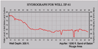
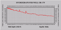
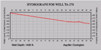
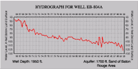
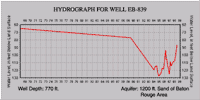
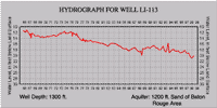
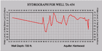
Geology of Evangeline Equivalent Aquifers

The Evangeline aquifer is composed of unnamed Pliocene sands and the Pliocene-Miocene Blounts Creek member of the Fleming formation. The Blounts Creek consists of sands, silts, and silty clays, with some gravel and lignite. The sands of the aquifer are moderately well to well sorted and fine to medium grained with interbedded coarse sand, silt, and clay. The mapped outcrop corresponds to the outcrop of the Blounts Creek member, but downdip, the aquifer thickens and includes Pliocene sand beds that do not outcrop. The confining clays of the Castor Creek member (Burkeville aquiclude) retard the movement of water between the Evangeline and the underlying Miocene aquifer systems. The Evangeline is separated in most areas from the overlying Chicot aquifer by clay beds; in some areas the clays are missing and the upper sands of the Evangeline are in direct contact with the lower sands and gravels of the Chicot.

Hydrogeology

Recharge to the Evangeline aquifer occurs by the direct infiltration of rainfall in interstream, upland outcrop areas and the movement of water through overlying terrace deposits, as well as leakage from other aquifers. Fresh water in the Evangeline is separated from water in stratigraphically equivalent deposits in southeast Louisiana by a saltwater ridge in the Mississippi River valley. The hydraulic conductivity of the Evangeline varies between 20-100 feet/day.

The maximum depths of occurrence of freshwater in the Evangeline range from 45.7 m (150 ft) above sea level, to 685.8 m (2,250 ft) below sea level. The range of thickness of the fresh water interval in the Evangeline is 15.2 m to 579.1 m (50 to 1,900 ft). The depths of the Evangeline wells that were monitored in conjunction with the Baseline Monitoring Project range from 58.8 m to 522.7 m (170 to 1,715 ft).

Text source: Baseline Monitoring Project, 2000, EPA Fiscal Years '98-'00 (State Fiscal Years '98-'00, July 1997 to June 2000), First Triennial Summary Report for the Environmental Evaluation Division of the Louisiana Department of Environmental Quality, http://www.deq.state.la.us/evaluation/aeps/triennial2000/index.htm

Map showing well sites.
Figure 44: Well location maps for hydrographs show in in Figure 45. Aquifers mentioned are of same horizon as Evangeline formation. Source: U.S. Geological Survey, Ground Water Resources of Louisiana.

Hydrograph for well ST-563 Hydrograph for well WF-254
Well ST-563 Well WF-254
Hydrograph for well ST-776 Hydrograph for well EF-61
Well ST-776 Well EF-61
Hydrograph for well OR-179 Hydrograph for well TA-278
Well OR-179 Well TA-278
Hydrograph for well EB-804A Hydrograph for well EB-839
Well EB-804A Well EB-839
Hydrograph for well LI-113 Hydrograph for well TA-454
Well LI-113 Well TA-454
Figure 45: Hydrographs of individual wells on an annual time scale. Also shown are well depths and aquifer names. Click on an individual image for a larger version of the hydrograph.

« Previous | Next »


Coastal & Marine Geology Program > Center for Coastal & Regional Marine Studies > Environmental Atlas of Lake Pontchartrain

FirstGov.govemail Feedback [an error occurred while processing this directive]