| |  |  | | Lake Pontchartrain Atlas: | | | | | | | | | | | | | | | | | | | | | | Physical Environments |  | | | | | | | | | | | | | | | | | | | | | | |  | | | | | | | | | | |  | Physical Environments - Circulation Contributors: Signell, List Except during Bonnet Carré Spillway openings, currents in Lake Pontchartrain are dominated by two basic processes: 1) changes in Lake level and 2) wind blowing over the Lake. When the Lake level changes, most of the water that enters or leaves the Lake must come through the Rigolets and Chef Menteur Passes on the east end of the Lake. This condition creates a pattern of currents that is strongest in the eastern end and then rapidly decreases in the open central Lake (Figure 36). These currents flow in the same direction from top to bottom. 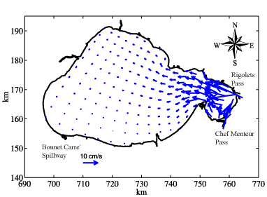 | | Figure 36: Depth-averages currents driven by a 10 cm/day (3.94 in/day) rise in Lake Pontchartrain water level. Length of arrow relates to current speed. An increase of 20 cm (7.87 in) in a day produces a current twice as fast. | 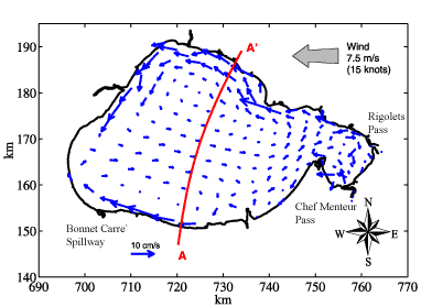 | | Figure 37: Depth-averaged currents driven by a 7.5 m/s (15 knots) easterly wind. Length of arrow relates to current speed. The red A-A' line gives the location of the vertical "slice" shown in Figure 38. A doubling of the wind speed produces a current twice as fast. | When the wind blows over the Lake, it generates a two-gyre pattern of depth-averaged currents that flow (downwind) along the shores parallel to the direction the wind and against the wind in the middle of the Lake (Figure 37). These currents, however, change strongly from top to bottom. While surface currents (Figure 38) are all downwind, a vertical slice reveals that currents in the center of the Lake reverse direction and flow in the opposite direction near the bottom (Figure 39). 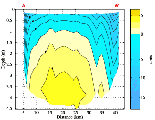 | | Figure 38: Depth variation of currents perpendicular to line marked A-A' in Figures 37 and 39. Strongest currents are downwind, in the shallows, and direction of flow changes from top to bottom over much of the lake. The color indicates the direction of current flow: blue = flow generally in the downward direction; yellow = flow generally in the up wind direction. | 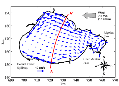 | | Figure 39: Surface currents driven by a 7.5 m/s (15 knots) easterly wind. Length of arrow relates to current speed. A doubling of the wind speed produces a current twice as fast. | Typical daily-averaged flows in the open central Lake are quite weak with typically stronger flows in the eastern Lake (Figure 40). The pattern of typical current strength shows some resemblance to the pattern of sediment type. 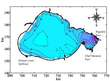 | | Figure 40: Modeled typical speed (cm/s) strength of daily depth-averaged currents per year in Lake Pontchartrain. The darker purple colors on the east end of the Lake indicates increased speed as it decreases in speed shown as the lighter blue colors. | « Previous | Next » |
