Texture, Carbonate Content, and Preliminary Maps of Surficial Sediments, Flower Garden Banks Area, Northwest Gulf of Mexico Outer Shelf, USGS Open-File Report 03-002
Home / Contents / Introduction / Setting / Methods / Previous Work / Discussion / Conclusions / Acknowledgments / References
Appendices: I. Field Report / II. Sediment Analysis / III. Table / Graphic / IV. Figures / V. Fig. Summary / VI. GIS/Metadata
Texture, Carbonate Content, and Preliminary Maps of Surficial Sediments of the Flower Garden Banks Area, Northwestern Gulf of Mexico Outer Shelf.
Introduction
The purpose of this report is to release texture and carbonate content data from 107 seafloor sediments collected within and near the East and West Flower Garden Banks areas of the Flower Garden Banks National Marine Sanctuary and to show relationships between these data and existing bathymetric data. The sediment data, in conjunction with previously collected multibeam bathymetry and backscatter data (Dartnell and Gardner, 1999), and biologic zonation maps (Rezak and others, 1985) were used to construct a reconnaissance-scale map of the distribution of seafloor sediment types. This map is intended for resource managers and can be used, with additional data, as a basis for future habitat mapping. The sediment data are presented in the text as simplified tables. The complete analytical data are provided as downloadable Excel files. Maps are provided as figures in the text and as a downloadable ArcView project so that users with access to ArcView may manipulate the display for their own purposes.
Back to TopSetting
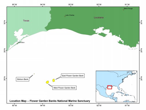
The Flower Garden Banks lie in the northwestern Gulf of Mexico on the outer continental shelf about 170 km due south of the Texas -Louisiana border (figure 1) and comprise the northernmost tropical coral reefs in the United States. Although fishermen have appreciated the productivity of the "Flower Gardens" for over 100 years, it was not until the 1970's that the general public began to urge that these fragile ecosystems be afforded protection. In 1992 three small areas were set aside as a National Marine Sanctuary.
 |
|
Figure 1: (click to enlarge 168 kb) Location map of the protected areas
that comprise the Flower Garden Banks National Marine Sanctuary. |
East Flower Garden Bank (EFGB) and West Flower Garden Bank (WFGB) lie at the shelf edge in regional water depths of 100 - 150m and encompass about 66 and 77 square kilometers, respectively. Stetson Bank lies about 55 km NW of WFGB in about 60 m of water and is less than four square kilometers in area. The tops of the reefs in these three areas rise dramatically above the surrounding seafloor, some to within 20 m of the water surface. A fortuitous combination of biological, geological, and oceanographic factors (including uplift of rock strata by upward flowing salt, the formation of submarine brine pools, and currents that deliver larvae from Caribbean reef organisms) allowed the formation of these isolated reefs, making them a fascinating and important natural laboratory for interdisciplinary studies.
Back to TopMethods
 |
|
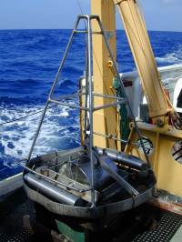
Figure 2: (click to enlarge 368 kb)) Photo of modified USGS vanVeen sediment sampler. |
One hundred and seven sediment samples were collected and analyzed for sediment grain size and CaCO3 content for this study. Approximately equal numbers of samples were collected from East Flower Garden Bank, West Flower Garden Bank, and the surrounding shelf. No samples were taken in or near Stetson Bank. All samples were collected during USGS cruise FERL01052 on the NOAA Research Vessel FERREL between 27 May 2001 and 02 June 2001 (see Appendix I for cruise report) using a modified Van Veen sediment grab sampler (figure 2). This sediment grab takes a relatively undisturbed sample about 32 cm by 32 cm in area and about 15 cm deep. The samples for analysis were taken from the upper 2 cm of the sediment in the grab.
All analyses were done in the USGS Sediment Lab in Woods Hole, Massachusetts. Grain size analyses were carried out according to procedures detailed in Poppe and Polloni (2000), and summarized in Appendix II. The percent of calcium carbonate material was determined by weight loss of 15 grams of bulk material after digestion with 10 percent HCl. The complete and simplified versions of the analytical data are included in Appendix II. For the purposes of this report, we used the sediment classification scheme of Folk (1974) to describe sediment types, but both Folk (1974) and Shepard (1954) nomenclature are recorded in Table 1.
Previous work
Scientists from NOAA, the oil industry, and academic institutions have carried out numerous studies of the biologic aspects of these fascinating coral reef and brine pool ecosystems both before and after the designation of the banks as a National Marine Sanctuary in 1992. However, geologic studies have been less numerous. Curray (1960) established the regional sedimentary framework for the northwestern Gulf of Mexico and Edwards (1971) first described sedimentary facies of West Flower Garden Bank. Rezak and others (1985) subsequently expanded Edwards' work to East Flower Garden Bank and the surrounding area. The USGS published preliminary maps of the topography, geologic structures, and sediment thickness of the East and West Flower Garden Banks more than a decade before the Sanctuary was created (Trippett, 1980). Ongoing studies by scientists and students at Lousiana State University, Texas A&M University, other academic institutions, and in NOAA's National Marine Sanctuary Program address aspects of the geology and physical habitat of the banks (much of this work is summarized in Rezak and others, 1985 and Roberts and others, 1999). Most recently, multibeam bathymetry and acoustic backscatter coverage of all three parts of the Flower Garden Banks National Marine Sanctuary were collected by the USGS (Dartnell and Gardner, 1999).
Back to TopDiscussion of Data
 |
|
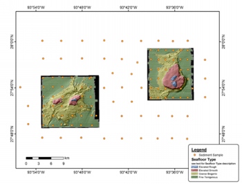
Figure 3: (click to enlarge 188 kb) sea-floor type interpretation with sample locations. |
Interpretation of sediment texture data from an area such as the Flower Garden Banks, where clastic terrigenous sediments are found in association with biogenic carbonate sediments, is not straightforward. For example, in a clastic depositional environment it can be assumed that the largest grains are related to the maximum current speed present during deposition. In a biogenic depositional environment the largest grains may be pieces of shell that are present because the animal lived and died there and has no bearing on the dynamics of sediment deposition. For this reason, we analyzed the CaCO3 content of each sediment sample, in addition to the texture. Samples that have a high percentage of CaCO3 (>60%) are assumed to be mainly biogenic in origin, whereas those low in CaCO3 (<40%) are assumed to be predominantly made up of clastic terrigenous sediments.
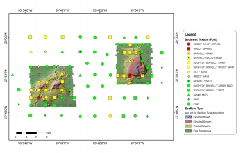 |
Figure 4: (click to enlarge 296 kb)
sea-floor type interpretation with texture data. |
For our map of sea floor types (figure 3) we have relied on the works of Trippet (1980), Rezak and others (1985), and Gardner and others (1998), and Dartnell and Gardner (1999) in addition to the new sedimentologic data to help define mappable units. Four major types of seafloor, described below, were identified in the East and West Flower Garden Banks area. To delineate the contacts between two of the bottom types, high-relief hardbottom and low-relief hardbottom, we relied on the multibeam bathymetry and acoustic backscatter data because no sediment samples were taken in those areas. The other two types, coarse-grained biogenic sediment and fine-grained terrigenous sediment, include areas outside of the Sanctuary boundaries, where no multibeam data have been collected. These seafloor types are defined by the texture (figure 4) and carbonate content (figure 5) of the sediment samples and the multibeam bathymetry and acoustic backscatter data were used to delineate contacts within the Sanctuary boundaries. Outside the Sanctuary boundaries, nearly all of the samples are fine-grained terrigenous sediment. We did not attempt to draw contacts in those parts of the study area with no multibeam data.
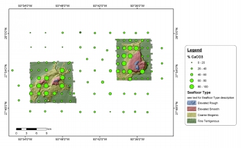 |
|
Figure 5: (click to enlarge 264 kb) sea-floor type interpretation with carbonate data. |
2. Low-relief hardbottom - These areas exhibit high acoustic backscatter, suggesting that they are hardbottom or coarse sand or gravel substrate. The multibeam bathymetry shows little small-scale relief. Rezak and others (1985) describe from diver observations a diverse bottom community of crustose corals and algae underlain by coarse carbonate sand or flat hardbottom. We did not attempt to sample sediments from this area. This type of seafloor surrounds each of the living reef areas and is found in an additional area in West Flower Garden that has no living reef associated with it. The slope away from the living reefs is very gradual between 40 - 50 m but steepens between 50 - 70 m.
3. Coarse-grained biogenic sediment - Acoustic backscatter is moderately high and patchy in nature in these areas. Our analyses show the texture of these sediments to be predominantly sand, but ranges from muddy sand to gravelly sand to muddy sandy gravel. The seafloor morphology in this area is complex and slopes gently away from the hardbottom areas. Carbonate contents are high, generally greater than 60%. This, together with qualitative visual inspections of the coarse fractions of the analyzed sediment samples, suggests that the sediment is mainly of biogenic origin, derived directly or indirectly from the nearby reefs. The areas closest to the high-relief hardbottom (i.e., living reefs) are covered by coarser biogenic sediments than more distal parts of this unit. This bottom type forms a very narrow band next to the low-relief hardbottom in some places and extends up to 5 km away from the low-relief hardbottom in other places. The bathymetry shows roughness that may be relict topography from buried or partially buried reefs.
4. Fine-grained terrigenous sediment - Acoustic backscatter in these areas is low. The carbonate contents of the samples are all below 60% and most are below 40%. The texture, based on our analyses, is mainly mud with varying amounts of sand and small amounts of gravel in some samples. The gravel fraction is made up of shells and shell fragments, whereas the finer grains appear to be predominantly clastic sediments of terrigenous origin. Circular pockmarks, presumably created by the release of gas through the sediments, are evident in the multibeam bathymetry of this bottom type, particularly on the seaward sides of both EFGB and WFGB, but also to a lesser extent, west of the banks (Gardner and others, 1998; Scanlon and others, in press). The seafloor is otherwise smooth and slopes very gently seaward.
An area of coarse-grained sediment (mainly muddy sand) is evident in the northwest corner of the study area, north of WFGB. Unlike other sediment samples classed as "sand" in unit 3 ("coarse-grained biogenic sediment") closer to the elevated reef areas, all of the samples from the northwest corner are low in carbonate content (between 11% and 23%), indicating that they are of mainly terrigenous origin.
Any sediment texture classification creates artificial boundaries between sediments of different types. In the real world, changes in sediment textures are typically gradational. The difference between samples classed as sandy mud and muddy sand, for example, may be less than a percentage point in sand content. Within each of the seafloor types described here, there is a great deal of consistency in the texture and carbonate content of the sediment samples. However, some variability exists because of the inherent "patchiness" of the natural world. In places, a sediment sample with texture or carbonate content differing from others nearby may be included within larger, more dominant, seafloor types.
Additional representations of the data described above are provided in Appendix IV so that users without access to GIS software can view a variety of combinations of our sediment analytical data overlain on multibeam bathymetry or acoustic backscatter maps of either East or West Flower Garden. Appendix V provides a summary table identifying which data are displayed in each of the figures in Appendix IV.
GIS data and metadata can be viewed and downloaded from Appendix VI. A ready-to-use ArcView project is included or files can be downloaded to add to an existing project. Instructions on how to download from the web the free GIS browser ArcExplorer are also included. Back to Top
Conclusions
Texture and carbonate content of the sediments in and around the East and West Flower Garden Banks show a clear pattern of variability related to proximity to the high-relief hardbottom or reef areas. Samples that were taken closest to the reefs (water depths between 70 - 120 m) have the highest carbonate content (generally >60%) and the coarsest texture (generally >50% sand or gravel). Those taken further from the reefs (water depths greater than 120 m) have less than 60% carbonate content and are finer-grained. This is expected because the coarse fraction is predominantly biogenic material derived from the reefs, whereas finer terrigenous material dominates further from the reefs. In addition, winnowing of fine sediments from the reef areas by currents focused by the topography may contribute to the grain size difference.
Further examination of the coarse fractions from the carbonate sediments could identify the organisms that created the material and provide information about habitat zones in the study area. Likewise, identification of the composition of the constituent grains and their condition could provide a key to understanding the age and origin of the terrigenous sediments. This information, together with additional biological, geological, physical, and chemical data will be useful for constructing habitat maps of the Sanctuary.
Acknowledgements
We thank the officers and crew of R/V FERREL for their professionalism during the fieldwork. D. Walsh (USGS) and D. Weaver (USGS) are thanked for their assistance with at sea operations. F. Wood (USGS) performed the sediment grain size and carbonate analyses. NOAA's Flower Garden Banks National Marine Sanctuary provided ship time and partial funding for this study. We are grateful to FGBNMS staff (particularly E. Hickerson and K. Buch) for assistance with cruise logistics. L. Poppe (USGS), V. Cross (USGS), and S. Colman (USGS) provided helpful reviews.
Back to TopReferences
Curray, J.R., 1960. Sediments and history of Holocene transgression, continental shelf, northwest Gulf of Mexico. In F.P. Shepard, F.B. Phleger, In T.H. Van Andel, Eds., Recent Sediments, Northwest Gulf of Mexico. AAPG, Tulsa, Oklahoma, pp. 221-266.
Dartnell, Peter and Gardner, J.V., 1999, Sea-Floor Images and Data from Multibeam Surveys in San Francisco Bay, Southern California, Hawaii, the Gulf of Mexico, and Lake Tahoe, California-Nevada. USGS Digital Data Series DDS-55, CD-ROM.
Edwards, G.S., 1971, Geology of the West Flower Garden Bank. Texas A&M Sea Grant Publication, TAMU-SG-71-215, 199p.
Folk, R.L., 1974, Petrology of sedimentary rocks. Hemphill Publishing Co., Austin, TX, 182 p.
Gardner, J.V., Mayer, L.A., Hughes Clarke, J.E., and Kleiner, Art, 1998. High-resolution multibeam bathymetry of East and West Flower Gardens and Stetson Banks, Gulf of Mexico. Gulf of Mexico Science, v. XVI, no. 2, pp. 131-143.
Poppe, L.J., and Polloni, C.F., 2000, USGS East-coast Sediment Analysis: Procedures, Database, and Georeferenced Displays. USGS Open-file Report 00-358, CD-ROM.
Rezak, Richard, Bright, T.J., and McGrail, D.W., 1985. Reefs and Banks of the Northwestern Gulf of Mexico, John Wiley and Sons, Inc., 259p.
Roberts, H.H., McBride, R.A., and Coleman, J.M., 1999. Outer shelf and slope geology of the Gulf of Mexico: an overview. In: Kumpf, Herb, Steidinger, Karen, and Sherman, Kenneth, eds., The Gulf of Mexico Large Marine Ecosystem, Blackwell Science, 704p.
Scanlon, K.M., Coleman, F.C., and Koenig, C.C., in press. Pockmarks on the outer shelf in the northern Gulf of Mexico: gas-release features or habitat modifications by fish? Symposium on the Effects of Fishing Activities on Benthic Habitats: Linking Geology, Biology, Socioeconomics, and Management, American Fisheries Society Special Issue.
Shepard, F.P., 1954, Nomenclature based on sand-silt-clay ratios: Journal Sedimentary Petrology, v.24, p. 151-158.
Trippet, Anita, 1980, Maps Showing Geology of East and West Flower Garden Banks, Northwest Gulf of Mexico. USGS Miscellaneous Field Studies Map MF-1232, 1 sheet.

Home / Contents / Introduction / Setting / Methods / Previous Work / Discussion / Conclusions / Acknowledgments / References
Appendices: I. Field Report / II. Sediment Analysis / III. Table / Graphic / IV. Figures / V. Fig. Summary / VI. GIS/Metadata
[an error occurred while processing this directive]