 |
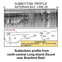
a83-220interp - Subbottom profile from north-central
Long Island Sound near Branford Reef (Needell and others,
1987). Profile location is shown on the bathymetric map
elsewhere in this report. Interpretation of the profile
shows the bedrock surface and the overlying glacial and
marine units. Gas at the boundary of the glacial and marine
units obscures much of the record. |
| |
|
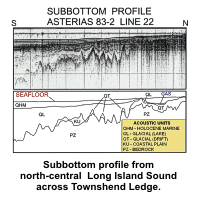 |
a83-222interp - Subbottom profile from north-central
Long Island Sound across Townshend Ledge (Needell and
others, 1987). Profile location is shown on the bathymetric
map elsewhere in this report. Interpretation of the profile
shows the bedrock surface and the overlying glacial and
marine units. Glacial drift crops out at the sea floor and
comprises Townshend Ledge. |
| |
|
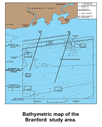 |
bathymap - Bathymetric map of the Branford, Connecticut
study area. Depths are in meters and are adjusted to mean
lower low water. Locations of seismic-reflection profiles 20
and 22, sample stations, and detailed images of the sidescan
sonar mosaic presented elsewhere in this report are
indicated. To view the detailed sidescan sonar images,
select the desired area from the map above. |
| |
|
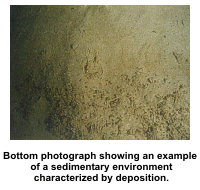 |
deposition - Bottom photograph showing an example of a
sedimentary environment characterized by deposition. Note
the muddy sediment and abundant polychaete and amphipod
tubes. Bottom photo is from Niantic Bay in Long Island Sound
(Poppe and others, 2000c). |
| |
|
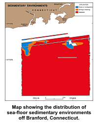 |
environments - Map showing the distribution of sea-floor
sedimentary environments off Branford, Connecticut. These
environments include: erosion or nondeposition, sorting or
reworking, and deposition. |
| |
|
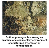 |
erosion - Bottom photograph showing an example of a
sedimentary environment characterized by erosion or
nondeposition. Note the gravelly sediment and sessile fauna.
Bottom photo is from Niantic Bay in Long Island Sound (Poppe
and others, 2000c). |
| |
|
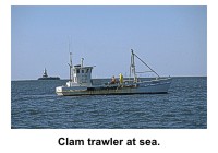 |
fishinga - Clam trawler at sea in north-central Long
Island Sound. |
| |
|
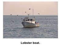 |
fishingc - Lobster boat pulling traps in Long Island
Sound. |
| |
|
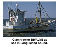 |
fishingd - Clam trawler BIVALVE at sea in north-central
Long Island Sound. |
| |
|
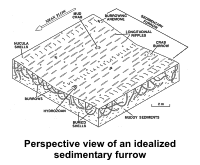 |
furrows1 - Perspective view of an idealized sedimentary
furrow in the muddy cohesive sediments of north-central Long
Island Sound. Figure shows the linear depression with gently
sloping walls, longitudinal ripples, bioturbation, and
nucula shells. |
| |
|
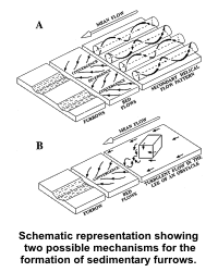 |
furrows2 - Schematic representation showing two possible
mechanisms (modified from Flood (1983) and McLean (1981),
respectively) for the formation of sedimentary furrows in
north-central Long Island Sound. (A) Secondary helical flow
patterns sweep coarse material, such as nucula shells or
sand, into linear zones of convergence. These relatively
coarse particles are driven by tidal currents and cut
furrows into soft, cohesive sediments. (B) Turbulent wakes
produced by flow around dredge-spoil disposal mounds or
other obstacles on the sea floor may also initiate furrow
development. Sand grains eroded from the mounds then abrade
the lengthening furrows into the soft seabed. |
| |
|
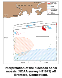 |
interpret - Interpretation of the sidescan sonar mosaic
(NOAA survey H11043) off Branford, Connecticut. The
different patterns are features that are defined in the
explanation and discussed in the text. |
| |
|
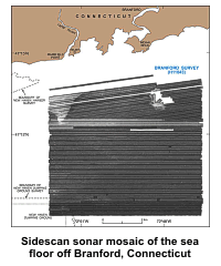 |
mosaic - Sidescan sonar mosaic of the sea floor off
Branford, Connecticut (NOAA survey H11043). Light tones on
the image represent areas of relatively high backscatter
(typically coarser grained sediments); dark tones represent
areas of relatively low backscatter (typically finer grained
sediments). |
| |
|
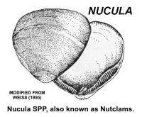 |
nucula - Nucula SPP, locally known as Nutclams, range up
to 6 mm long and are common in muddy bottom sediments within
Long Island Sound. |
| |
|
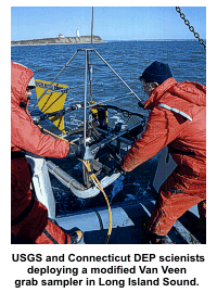 |
sampling - Image shows USGS and Connecticut DEP
scientists deploying a modified Van Veen grab sampler in
Long Island Sound. This sampler is equipped with both still
and video cameras. |
| |
|
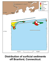 |
sediment - Distribution of surficial sediments off
Branford, Connecticut. Interpretation of the sediment
distribution is based on data from sampling stations (sample
locations are shown on the bathymetric map elsewhere in this
report), on tonal changes in backscatter on the sidescan
sonar image, and on correlation of the textural and
backscatter data with the bathymetry. |
| |
|
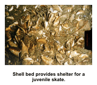 |
shellbed - Bottom photograph shows an example of a shell
bed providing shelter for a juvenile skate. Bottom photo is
from Niantic Bay in Long Island Sound (Poppe and others,
2000c). |
| |
|
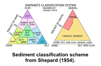 |
shepfig - Sediment classification scheme from Shepard
(1954) as modified by Schlee (1973). |
| |
|
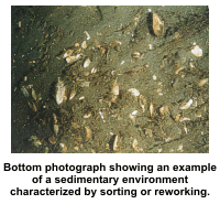 |
sortrewk - Bottom photograph showing an example of a
sedimentary environment characterized by sorting or
reworking. Note the sandy muddy sediment and abundant shell
debris. Bottom photo is from Niantic Bay in Long Island
Sound (Poppe and others, 2000c). |
| |
|
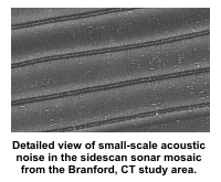 |
ssanoise - Detailed view of small-scale acoustic noise
in the sidescan sonar mosaic from the Branford, Connecticut
study area. Noise may be related to water-column events or
geometric effects related to the sidescan sonar's angle of
incidence with the sea floor. |
| |
|
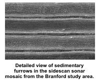 |
sssfurrows - Detailed view of sedimentary furrows in the
sidescan sonar mosaic from the Branford, Connecticut study
area. "Tuning fork" joining pattern exhibited by some of the
furrows typically open to the east (right) suggesting net
westward transport. Location of this view is shown in the
bathymetric figure; distribution of sedimentary furrows on
the mosaic is shown in the interpretation figure. |
| |
|
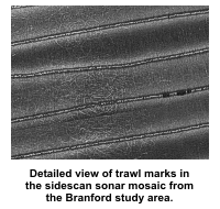 |
ssshclamtrawls - Detailed view of trawl marks in the
sidescan sonar mosaic from the Branford, Connecticut study
area. Looped curvilinear trawl marks result from commercial
hard-clam fishing. Location of this view is shown in the
bathymetric figure. |
| |
|
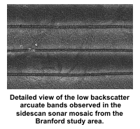 |
ssslowbarcs - Detailed view of the low backscatter
arcuate bands observed in the sidescan sonar mosaic from the
Branford, Connecticut study area. Location of this view is
shown in the bathymetric figure. |
| |
|
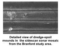 |
sssspoils - Detailed view of dredge-spoil mounds in the
sidescan sonar mosaic from the Branford, Connecticut study
area. Note the association of a sedimentary furrow with a
dredge spoil mound. The extension of furrows on the right
off both the east and west sides of the dredge spoil is
evidence for the oscillatory nature of the tidal currents.
Location of this view is shown in the bathymetric figure. |
| |
|
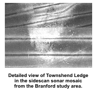 |
ssstownshend - Detailed view of Townshend Ledge in the
sidescan sonar mosaic from the Branford, Connecticut study
area. This rocky feature is an outcrop of the Madison
moraine. Location of this view is shown in the bathymetric
figure. |
| |
|
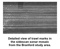 |
ssstrawlmarks - Detailed view of trawl marks in the
sidescan sonar mosaic from the Branford, Connecticut study
area. Location of this view is shown in the bathymetric
figure; distribution of trawl marks on the mosaic is shown
in the interpretation figure. |
| |
|
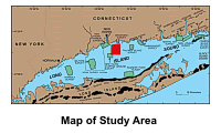 |
studylocationmap - Map showing location of the Branford,
Connecticut study area (red polygon). Also shown are major
onshore moraines, and the sites of other interpreted
sidescan sonar surveys in Long Island Sound: Norwalk --
Twichell and others (1997); Milford -- Twichell and others
(1998); New Haven Harbor and New Haven Dumping Grounds --
Poppe and others (2001); Roanoke Point -- Poppe and others
(1999a); Falkner Island -- Poppe and others (1999b);
Hammonasset -- Poppe and others (1997); Niantic Bay -- Poppe
and others (1998a); New London -- Poppe and others (1992),
Moffett and others (1994), Zajac and others (2000, 2003);
Fishers Island Sound -- Poppe and others (1998b). NOAA
sidescan sonar survey H11044, shown by a dashed line, has
not yet been interpreted. |
| |
|
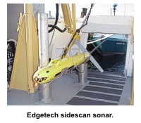 |
towfish - Edgetech (EG&G) 272T sidescan sonar tow fish
used aboard the RUDE for data acquisition during NOAA survey
H11043. |
| |
|
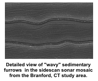 |
waveyf - Detailed view of "wavy" sedimentary furrows in
the sidescan sonar mosaic from the Branford, Connecticut
study area. Sinuous character of these furrows is related to
an irregular ship's track. |
