|

OFR 2004-1003 Home
Introduction
Geologic Setting
Data
Acquisition and Processing
Sidescan
Imagery
GIS Data Catalog
References
Figures List
Acknowledgments
Contacts
Disclaimer
README
|
INTRODUCTION
The
U.S. Geological Survey
(USGS), in cooperation with the
National Oceanic and Atmospheric Administration (NOAA) and the
Connecticut Department of Environmental Protection
(CT DEP),
 has
produced detailed geologic maps of the sea floor in Long Island Sound, a
major East Coast estuary surrounded by the most densely populated region
of the United States. These studies have built upon cooperative research
between the USGS
and the State of Connecticut that was initiated in 1982. The current
phase of this research program is directed toward studies of sea-floor
sediment distribution, processes that control sediment distribution,
nearshore environmental concerns, and the relation of benthic community
structures to the sea-floor geology. has
produced detailed geologic maps of the sea floor in Long Island Sound, a
major East Coast estuary surrounded by the most densely populated region
of the United States. These studies have built upon cooperative research
between the USGS
and the State of Connecticut that was initiated in 1982. The current
phase of this research program is directed toward studies of sea-floor
sediment distribution, processes that control sediment distribution,
nearshore environmental concerns, and the relation of benthic community
structures to the sea-floor geology.
Anthropogenic wastes, toxic chemicals, and changes in land-use
patterns resulting from residential, commercial, and recreational
development have stressed the environment of the Sound, causing
degradation and potential loss of benthic habitats (Koppelman and
others, 1976; Long Island Sound Study, 1994). Detailed maps of the sea
floor are needed to help evaluate the extent of adverse impacts and to
help wisely manage resources in the future. Therefore, in a continuing
effort to better understand Long Island Sound, we are constructing and
interpreting sidescan sonar mosaics (complete-coverage acoustic images
of the sea floor) within specific areas of special interest (Poppe and
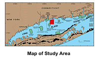
Polloni, 1998). The mosaic presented herein, which was produced during
survey H11043 by
NOAA 's Atlantic Hydrographic Branch, covers approximately 41.1
km2 of the sea floor in north-central Long Island Sound off
Branford, Connecticut.
 The
mosaic and its interpretation serve many purposes, including: (1)
defining the geological variability of the sea floor, which is one of
the primary controls of benthic habitat diversity; (2) improving our
understanding of the processes that control the distribution and
transport of bottom sediments and the distribution of benthic habitats
and associated infaunal community structures; and (3) providing a
detailed framework for future research, monitoring, and management
activities. The sidescan sonar mosaic also serves as a base map for
subsequent sedimentological, geochemical, and biological observations,
because precise information on environmental setting is important for
selection of sampling sites and for appropriate interpretation of point
measurements. The
mosaic and its interpretation serve many purposes, including: (1)
defining the geological variability of the sea floor, which is one of
the primary controls of benthic habitat diversity; (2) improving our
understanding of the processes that control the distribution and
transport of bottom sediments and the distribution of benthic habitats
and associated infaunal community structures; and (3) providing a
detailed framework for future research, monitoring, and management
activities. The sidescan sonar mosaic also serves as a base map for
subsequent sedimentological, geochemical, and biological observations,
because precise information on environmental setting is important for
selection of sampling sites and for appropriate interpretation of point
measurements.
|
