|
|
| Coastal and Marine Geology Program | Woods Hole Science Center |
U.S. Geological Survey Open-File Report 2004-1003
|
Geologic Setting |
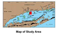
GEOLOGIC SETTINGLong Island Sound is 182 km long and as
much as 32 km wide. It is bordered on the
The study area,
NOAA survey H11043, covers about 41.1 km2 off the
central Connecticut shoreline, imaging an area seaward of the Branford
quadrangle (Flint, 1964). This quadrangle The bedrock across much of south-central and southeastern Connecticut is unconformably overlain by two tills, one of pre-Wisconsinan age, the Lake Chamberlain till, and one of late Wisconsinan age, the Hamden till (Flint, 1965; Schafer and Hartshorn, 1965; Flint and Gebert, 1976; Stone and others, 1992). The younger till forms a thin (0-5 m), discontinuous mantle over nearly all of the higher land across the Branford Quadrangle. This till is exposed onshore around Mansfield Point and Indian Neck (Flint, 1964; Stone and others, 1992). Although both tills have been identified in the Mount Carmel quadrangle located to the northwest (Flint, 1962), the older till has not been found in the Branford quadrangle and, if present, probably lies buried in some of the deeper valleys (Flint, 1964). The northward retreat of the late Wisconsinan ice sheet is marked in southeastern Connecticut by a succession of minor recessional moraines (including the Madison, Hammonasset-Ledyard, Old Saybrook, and Mystic moraines. The Madison moraine, which trends east northeast, is exposed near Hogshead and Chipman Points in the adjoining Guilford quadrangle and presumably extends offshore across the northern part of the study area (Flint, 1971, Flint and Gebert, 1976; Stone and others, 1998). Stratified drift, deposited in contact with the melting ice near the glacier margin, blankets the till and bedrock over parts of the Branford quadrangle (Flint, 1964). Stratified drift deposited by glacial streams as outwash, is present onshore as part of the Farm River valley train (Flint, 1964; Stone and others, 1992) and offshore as valley-fill deposits (Stone and others, 1998). Deltaic sediments and proximal and distal lacustrine fan facies deposited in glacial Lake Connecticut overlie both bedrock and glacial drift within the study area and extend about 9.5 km south of Mansfield Point (Lewis and Stone, 1991; Stone and others, 1992; Stone and others, 1998). This lake, which occupied most of the Long Island Sound basin, was formed when the ice front began to recede from the Harbor Hill-Roanoke Point-Charlestown moraine position and meltwater was impounded in the expanding, long, narrow basin between the moraine and the retreating ice to the north (Stone and Borns, 1986). The glaciolacustrine deposits of glacial Lake Connecticut and the underlying glacial drift are truncated by a regional unconformity. This unconformity is a composite product of the subaerial exposure, which occurred after glacial Lake Connecticut drained, and before the marine transgression, which took place after 15 ka (Needell and others, 1987; Lewis and Stone, 1991). Marine deposits, which occur in quiet-water areas throughout the Long Island Sound basin, overlie the unconformity and earlier deposits, and they record deposition during the postglacial Holocene eustatic rise of sea level (Lewis and DiGiacomo-Cohen, 2000). The Central Long Island Sound Disposal Site, which is partially located within the study area and about 10.4 km south of Mansfield Point, covers about 6.7 km2 in north-central Long Island Sound. This area and three other open-water disposal sites within the Sound (Eatons Neck, Bridgeport, and New London) historically have received the vast majority of the spoils dredged from the borders of the Sound. For example, during 1954 and 1956 more than 4 million cubic meters were dumped at the New Haven site (Schubel and others, 1979). During the period October 1993 through January 1994 the U.S. Army Corps of Engineers dredged approximately 642,000 cubic meters of sediments from the navigational channel in New Haven Harbor, which were then disposed at the New Haven Dumping Ground (Bohlen and others, 1996). The New Haven Dumping Ground continues to be one of the most active disposal sites in New England because its proximity to major commercial and recreational port facilities minimizes disposal costs (Boyd and others, 1972) and because it is characterized by relatively weak bottom current is thought to be located in a depositional sedimentary environment (Morris and others, 1996). Tidal and wind-driven currents have extensively reworked both the glacial and postglacial deposits south of Branford and continue to influence the sedimentary processes and surficial sediment distributions in the study area (Lewis and Stone, 1991; Lewis and DiGiacomo-Cohen, 2000). Tidal currents alone locally exceed 20 cm/s at 1 to 2 m above the bottom across the study area (Gordon and others, 1972; Signell and others, 2000; Knebel and Poppe, 2000). |