|
|
| Coastal and Marine Geology Program | Woods Hole Science Center |
U.S. Geological Survey Open-File Report 2004-1003
|
Data Acquisition and Processing Sidescan Imagery
|
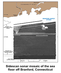
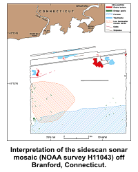
SIDESCAN SONAR IMAGERY The sidescan sonar mosaic of the sea floor off Branford, Connecticut
NOAA
survey
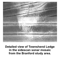
Rocky and Gravelly AreasThe complex patches of high and low backscatter with individual
high-backscatter targets represent rocky, bouldery areas. Rocky patches,
which correspond to Townshend Ledge, Branford Reef and several smaller
unnamed features, occur in the northern part of the image, and contain
boulders that exceed 3 m in
Isolated spots of high backscatter, not associated with water-column disturbances, are scattered along the northern part of the study area. These spots represent individual boulders, probably glacial erratics, and small patches of bouldery bottom. Depressions adjacent to the boulders caused by scour and linear accumulations of sediment in the current shadows of the boulders attest to the strong oscillatory nature of the tidal currents. Light and Dark AreasAreas characterized by relatively high backscatter, which occur adjacent to deposits of boulders and gravel on Townshend Ledge and Branford Reef, primarily coincide with exposures of glaciodeltaic deposits (Stone and others, 1998) and with sediments that have been winnowed from the crests of the bathymetric highs. The high backscatter tends to be produced by coarser-grained sediments, typically gravelly sand and sand.
The central and southern parts of the study area are characterized by
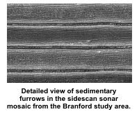
relatively low Sedimentary Furrows
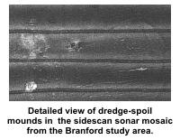
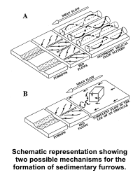
Most of the sedimentary furrows appear to gradually taper out at both ends, although the ends of some furrows show a "tuning fork" joining pattern. The junctions open predominantly toward the east, but some also open toward the west. A few of the sedimentary furrows cross, start at, or end at dredge-spoil mounds, but most are not associated with the mounds or with any other identifiable bottom features. Bottom video and high-resolution seismic-reflection profiles
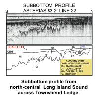
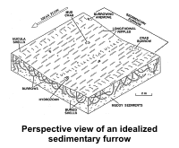
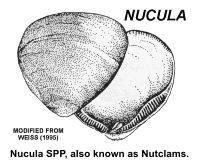
collected as part of an earlier Although the deeper waters of north-central Long Island Sound are long-term depositional areas characterized by fine-grained, cohesive sediments (Poppe and others, 2000a) and relatively weak bottom currents (Signell and others, 2000; Knebel and Poppe, 2000), the presence of sedimentary furrows indicates localized sediment erosion or transport and environments that have recurring, directionally stable, and occasionally strong currents (Dyer, 1970; Lonsdale and others, 1973; Hollister and others, 1974; Flood, 1983). The lack of abrupt lithologic transitions, the faint appearance of the associated longitudinal ripples, and the abundance of tracks made by bottom-dwelling animals suggest that the processes that created these furrows are slow or only intermittently active. In any case, the furrows are not relict. Relict features would have been either obliterated by bioturbation or by the relatively high postglacial sedimentation rates within the study area (Lewis and DiGiacomo-Cohen, 2000). Previous work near the New Haven Dumping Ground (Gordon and others, 1972; Signell and others, 2000; Poppe and others, 2001) indicates that (1) resuspension is the major mechanism of bottom sediment transport; (2) once suspended, sediment does not entirely settle out between tidal cycles, and (3) benthic biological activity, rather than currents, is responsible for most of the sediment resuspension. While it is true that the currents in the north-central Sound are usually not strong enough to initiate erosion, once sediments are resuspended by biological activity, the currents can transport them. The "tuning fork" joining patterns of the furrows, which usually open toward the east, indicate net westward sediment transport (Dyer, 1970; Flood, 1983). However, because adjacent furrow junctions do occasionally open in opposite directions, these joining patterns also suggest that the tidal regime is important to furrow formation and that the furrows can form when water flows in either direction. Studies by Flood (1981, 1983) also show that coarse-grained sediments are also important for the initiation and development of furrows in muddy sediments. Coarse sediments that are available within the study area include nutclam shells and sand associated with the dredge spoils. Given the geometry of the basin and conditions in the Branford study area, we can offer two possible mechanisms that could produce and maintain the sedimentary furrows in north-central Long Island Sound. In the first mechanism, adapted from Flood (1983), benthic biologic activity resuspends nutclam shells. Then, secondary helical-flow patterns produced by the tidal currents, which develop just above the sea floor, align the nutclam shell debris mobilized by biological activity into convergent flow zones (Hollister and others, 1974; Mclean, 1981). Furrow development is initiated due to enhanced erosion within the elongate shell beds caused by abrasion (related primarily to sediment resuspension from the impacts of saltating shells) and from current scour around individual shells. The furrows lengthen as the concentrated shells move downstream in the bottom currents.
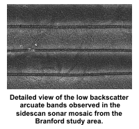
In summary, the elongate geometry and regional bathymetric contours of Long Island Sound combine to constrain the tidal and storm currents and cause dominantly east-west flow directions. These conditions, in turn, produce the helical flow patterns that are conducive to the development of erosional furrows (Poppe and others, 2002b). Through resuspension due to biological activity and the subsequent development of sedimentary furrows and longitudinal ripples, fine-grained cohesive sediment can be remobilized, and, at least episodically, be made available for transport farther westward into the estuary (Poppe and others, 2002b). Arcuate Bands of Low Backscatter
If these features were primarily related to fine-grained down-slope transport pathways, then we would expect only their southern ends to be bent toward the west, reflecting the directional effects of net bottom-sediment transport. Inasmuch as both the northern and southern ends are deflected westward, however, these features may represent bands of fine-grained sediment moving westward in a manner similar to that of barchan dunes. Current models for the southern part of the Branford study are do show net westward bottom transport (Signell and others, 2000). Trawl Marks
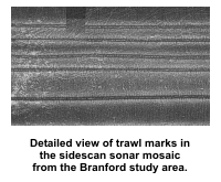
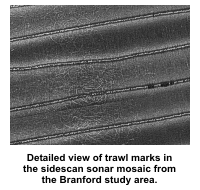
Some of the trawl marks have a looping appearance. These trawl marks
probably owe their extreme curvature to (1) the side-mounted deployment
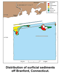
of Distribution of Surficial SedimentsGravel, including boulders, occurs on the crests of
Townshend Ledge, Branford Reef, and on isolated bathymetric highs
that trend toward the east-northeast across the northern part of the
study area. These coarse deposits are associated with outcrops of
glacial drift, and are probably lag deposits resulting from the
reworking of these deposits by the tidal current and waves. Tonal
changes on the sidescan sonar mosaic suggest that small-scattered
patches of sand and silty
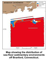
Aprons of sand silt clay and, around Townshend Ledge, silty sand separate the coarser grained sediments from the muds. These sandy and muddy sediments are very poorly sorted, nearly symmetrical, and platykurtic. Clayey silt, occasionally grading to silt, is the dominant sediment type in the study area, covering almost the entire north-central, central, and southern parts. These muddy cohesive sediments are typically poorly to very poorly sorted, coarse skewed to nearly symmetrical, and platykurtic to mesokurtic. Although presented here in much greater detail, the sediment distribution in the study area is similar to this part of the regional distribution reported by Poppe and others (2000a). Distribution of Sedimentary EnvironmentsThree sedimentary environments are mapped within the study area on
the basis of samples, tonal changes in the
sidescan sonar mosaic, and
bathymetry. These include environments characterized by
erosion or nondeposition,
sorting or reworking, and
deposition. These environments represent the dominant long-term
conditions and may not always reflect small-scale or intermittent
processes. For example, erosional bedforms such as longitudinal ripples Environments characterized by erosion or nondeposition, which reflect high-energy conditions (Knebel and Poppe, 2000; Poppe and others, 2000c), prevail in the relatively shallow waters around Townshend Ledge, Branford Reef, and a few isolated bathymetric highs across the northern part of the study area. Strong tidal currents and wind-driven waves prevent the deposition of Holocene marine sediments and erode the finer fraction from the sea-floor sediments, leaving exposed lag deposits of boulders and gravel. Scour features, which are typically present around isolated boulders and cobbles, are most conspicuous northeast of Townshend Ledge. As water depth increases, the strength of storm and tidal currents at the sea floor decreases. Conditions favoring erosion or nondeposition are replaced by sedimentary environments characterized by sediment sorting or reworking. Faint current ripples, observed on the surface of grab samples of sandy muds and muddy sands, and sediment resuspension, observed in bottom video, reflect this constant sorting by tidal and storm currents. Hermit crabs, starfish, and shell debris are locally common in bottom video. The central and southern parts of the study area are characterized predominantly by long-term deposition. In these areas fine-grained sediments accumulate in the deeper, lower energy environments protected from strong tidal and storm conditions. Amphipod and polychaete tubes, shrimp burrows, and snail and rock crab tracks are locally common in these muddy sediments. Although presented here in greater detail, the distribution of sedimentary environments in the study area is similar to this part of the regional distribution reported by Knebel and Poppe (2000). |