Link to USGS home page Link to USGS home page
Coastal and Marine Geology Program
Coastal & Marine Geology Program > South Carolina Coastal Erosion Study > Open File Report 2004-1013

Maps Showing the Stratigraphic Framework of South Carolina's Long Bay from Little River to Winyah Bay

USGS Open File Report 2004-1013

by: Wayne E. Baldwin, Robert A. Morton, Jane F. Denny, Shawn V. Dadisman, William C. Schwab, Paul T. Gayes, and Neal W. Driscoll

Introduction
Setting
Geophysical Data:
Acquisition
Processing &
Interpretation
Mapping Results:
Bathymetry &
Sidescan Sonar
Seismic
Stratigraphy
Summary
Acknowledg-
ments
References
List of Figures
Disclaimer

Introduction

Regional map display.  Inset map of South Carolina and blow up images of the South Carolina portions of both Phase I and Phase II study areas for the South Carolina/Georgia Coastal Erosion Study.
Figure 1. Regional map display. Inset map of South Carolina and blow up images of the South Carolina portions of both Phase I and Phase II study areas for the South Carolina/Georgia Coastal Erosion Study. Islands, beaches and major water bodies are labeled. Detailed location map from Figure 2 is outlined in red within the Phase II study area (modified from Baldwin, 2002). [larger version]
South Carolina's Grand Strand is a heavily populated coastal region that supports a large tourism industry. Like most densely developed coastal communities, the potential for property damage and lost revenues associated with coastal erosion and vulnerability to severe storms is of great concern. In response to these concerns, the U.S. Geological Survey (USGS) and the South Carolina Sea Grant Consortium have chosen to focus upon the Grand Strand (the arcuate strand of beaches between the North Carolina Border and Winyah Bay, SC) and adjacent Long Bay (Figures 1 and 2) as a portion of Phase II of the South Carolina/Georgia Coastal Erosion Study (SC/GCES).

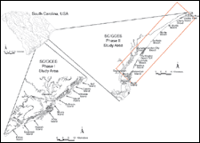
Phase I of the SC/GCES (1994 - 1999) focused upon critical areas of erosion along the central portion of the South Carolina coastline (Figure 1). Research conducted during Phase I began to identify how physical processes, inlet-beach interaction, framework geology and shoreline geometry combine to control patterns of erosion along the central South Carolina coast. Phase II of SC/GCES (1999 - present) was designed to gain a further understanding of the factors affecting shoreline change within northern South Carolina (Figure 1) and Georgia. Specific goals of the Phase II study include: 1) quantifying historic shoreline change and identifying erosional hotspots; 2) mapping geologic framework and determining its role in the area's coastal evolution; and 3) calculating a sediment budget and identifying transport mechanisms within the study area.

Map showing location of study area.
Figure 2. Map showing location of study area. Geophysical tracklines are color coded based on survey year and sub-bottom data type. Also depicted are local municipalities, landmarks, water bodies and rivers. Inset provides regional orientation, including identification of influential structural arches (Cape Fear Arch (CFA), Mid-Carolina Platform High (MCPH)) and embayments, capes and water bodies. Piedmont draining rivers are displayed in red (inset). Inland Cretaceous/Tertiary contact in orange approximated from Owens (1990). [larger version]

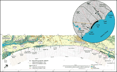
In November 1999, to address the second goal of Phase II of the SC/GCES, the USGS, Coastal Carolina University (CCU) and Scripps Institution of Oceanography (SIO) began a program to systematically map the geologic framework within the South Carolina segment of Long Bay (Figures 1 and 2). Data sources used to produce these maps include high-resolution sidescan-sonar, interferometric sonar swath bathymetry and sub-bottom profiling. Surface sediment samples, vibracores and video data provide groundtruth for the geophysical data. The goals of the program include determining regional-scale sand-resource availability (needed for ongoing beach nourishment projects) and investigating the role that inner-shelf morphology and geologic framework play in the evolution of this portion of coastal South Carolina.

This report presents preliminary maps generated through integrated interpretation of geophysical data, which detail the geometries of Cretaceous and Tertiary continental shelf deposits, show the location and extent of paleochannel incisions, and define a regional transgressive unconformity and overlying bodies of reworked sediment. Defining the shallow sub-surface geologic framework will provide a base for future process-oriented studies and provide insight into coastal evolution.

Introduction | Setting | Geophysical Data: Acquisition | Geophysical Data: Processing & Interpretation | Mapping Results: Bathymetry & Sidescan Sonar | Maping Results: Seismic Stratigraphy | Summary | Acknowledgements | References | List of Figures | Disclaimer

Printable version of OFR 2004-1013Printable Version


Related Research Projects:

South Carolina Coastal Erosion Study
USGS Coastal & Marine Geology Program

Related Links:

Center for Coastal & Regional Marine Studies
USGS

South Carolina Sea Grant Consortium
State of South Carolina

Coastal Carolina University

Scripps Institution of Oceanography
University of California


Coastal & Marine Geology Program > South Carolina Coastal Erosion Study > Open File Report 2004-1013


[an error occurred while processing this directive]