Home Page
Mosaic & Explanation
GIS Data
Contacts
About this Disk
|
GIS Data
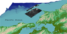
3D Views
Interactive Visualization
Systems (IVS) Fledermaus software was used to view the spatially
referenced sidescan-sonar mosaic image within a three-dimensional
view of the Gulf of the Farallones topographic data generated from
the NGDC coastal relief model. These three-dimensional perspective
files are saved in a 'scene' file. The Fledermaus
software also enables the user to 'fly through' the study area, presenting
unique perspectives, and again, improving data interpretation.
IVS also produces a free viewer, iView3D, that will
read files generated by the Fledermaus software, which is downloadable
from the IVS Website.
Fledermaus Scene and Movie Files:
The following Fledermaus data files are stored within the ivs
directory:
- farallones.scene - 3-D
perspective file containing sidescan-sonar mosaic image file
and topography viewable with Feldermaus or iView3D
- farallones.mpg - movie
fly through of study area
|