Home Page
Mosaic &
Explanation
GIS Data
Contacts
About this Disk
|
Introduction
Click on figures for larger view.
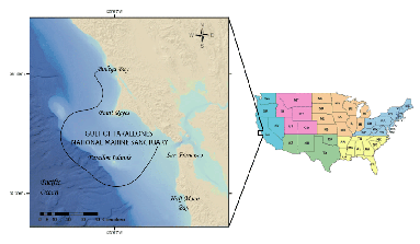
In 1989, the U.S. Geological Survey (USGS) began a major geologic
and oceanographic investigation of the Gulf of the Farallones National Marine Sanctuary continental
shelf system (Figure 1),
designed to evaluate and monitor human impacts on the marine environment
(Karl and others, 2002).
The study region is located off the central California coast, adjacent
to San Francisco Bay and encompasses the Gulf of Farallones Marine
Sanctuary. Geologic mapping of this area included the use of various
remote sensing and sampling techniques such as shallow sub-bottom
profiling, sidescan-sonar and bathymetric mapping, gravity core
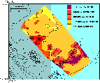
and grab sampling, and photography. These data were used to define
the surficial sediment distribution (Figure
2), underlying structure and sea floor morphology of the study
area.
The primary focus of this report is to present a georeferenced,
digital sidescan-sonar mosaic of the study region.
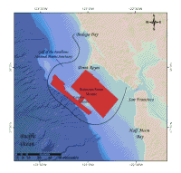
The sidescan-sonar data were acquired with the AMS-120 (120 kHz) sidescan-sonar system during USGS cruise F9-89-NC. The dataset covers approximately 1000 km² of the continental
shelf between Point Reyes, California and Half Moon Bay, California,
extending west to the continental shelf break near the Farallon
Islands (Figure 3). The sidescan-sonar
mosaic displays a heterogenous sea-floor environment, containing
outcropping rock, ripples, dunes, lineations and depressions, as
well as flat, featureless sea floor (Karl and
others, 2002). These data, along with sub-bottom interpretation (Chin
and others, 1997) and ground truth data (Maher
and others, 1991) define the geologic framework of the region.
The sidescan-sonar mosaic can be used with supplemental remote sensing
and sampling data as a base for future research, helping to define the local current regime and predominant sediment transport directions and forcing conditions within the Gulf of Farallones.
To view files in PDF format, download
free copy of Adobe Reader http://www.adobe.com/products/acrobat/alternate.html.
|