The Gulf of the Farallones: Sidescan-Sonar Imagery,
USGS
Open-File Report 2004-1082
Home Page
Mosaic & Explanation
GIS
Data
Data Description
Download Files
3D Views
Contacts
About this Disk
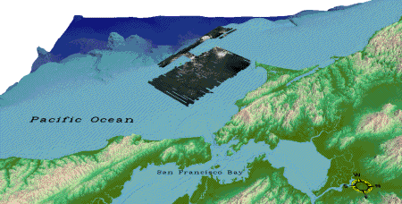
Figure 7.
Three-dimensional view of the sidescan-sonar and coastal relief image in the Gulf of the Farallones. Elevation range: -3800 (dark blue) - +1450 (light brown).
Click on figure for larger image
.
Back GIS Data -
3D
Views
Home Page
/
Mosaic & Explanation
/
GIS
Data
/
Contacts
/
About this Disk
[an error occurred while processing this directive]