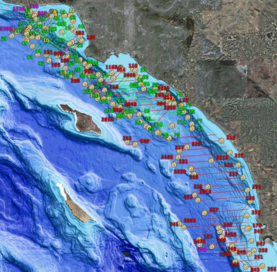
The overall project study area extends from Point Conception south to the Mexican border (figure 1). Over a four
year period multichannel seismic-reflection (MCS) data were collected from Point
Dume to the Mexican border (see trackline map).
1997: Santa Monica Bay, R/V Sproul (Cruise ID: S-1-97-SC)
(8 lines, 192 km) - 30 hours into operations, the failure of the air compressor forced an
early halt to MCS data collection. The remainder of the cruise was dedicated to
collection of 3.5 kHz high-resolution reflection profiles.
1998: Point Dume to Dana Point - R/V Auriga (Cruise ID: A-1-98-SC)
(76 lines, 1234 km) - During the first 48 hours of MCS operations, a
backup streamer (24-channel, 6.25m group interval) was deployed while repairs were
being made to the primary streamer deck leader. The primary streamer
(24-channel, 10m group interval) was brought back online for the remainder of the cruise.
For the last 46 hours of MCS recording, the backup Bolt airgun was deployed due to a
failure of the GI gun. This source could be triggered with a shorter shot interval (6 seconds)
resulting in a doubling of CMP trace fold. See Normark et al (1999a) for operation details.
1999: Redondo Beach to San Diego - R/V Ocean Olympic (Cruise ID: O-1-99-SC)
(62 lines, 1100 km) - There were no recording parameter changes or
equipment malfunctions. Because of state and federal regulations, MCS operation could only be conducted
during daylight hours when a sufficient mammal watch radius could be provided. Regulations and permit process are
described in Childs et al, 1999. See Normark et al (1999b) for operation details.
2000: Point Dume and San Diego - R/V Auriga (Cruise ID: A-1-00-SC)
(7 lines, 74 km) - Because of system problems, the MCS source (a 2 kiloJoule minisparker) functioned only intermittently
throughout the cruise. As a result, only eight lines of MCS data were collected in deep water: seven
lines south of Point Dume and one test line due west of San Diego. See Gutmacher et al (2000) for operation details.
