U.S. Geological Survey Open-File Report 2005–1423
Radon in Soils of Parts of Cameron, Hidalgo, and Willacy Counties, Texas
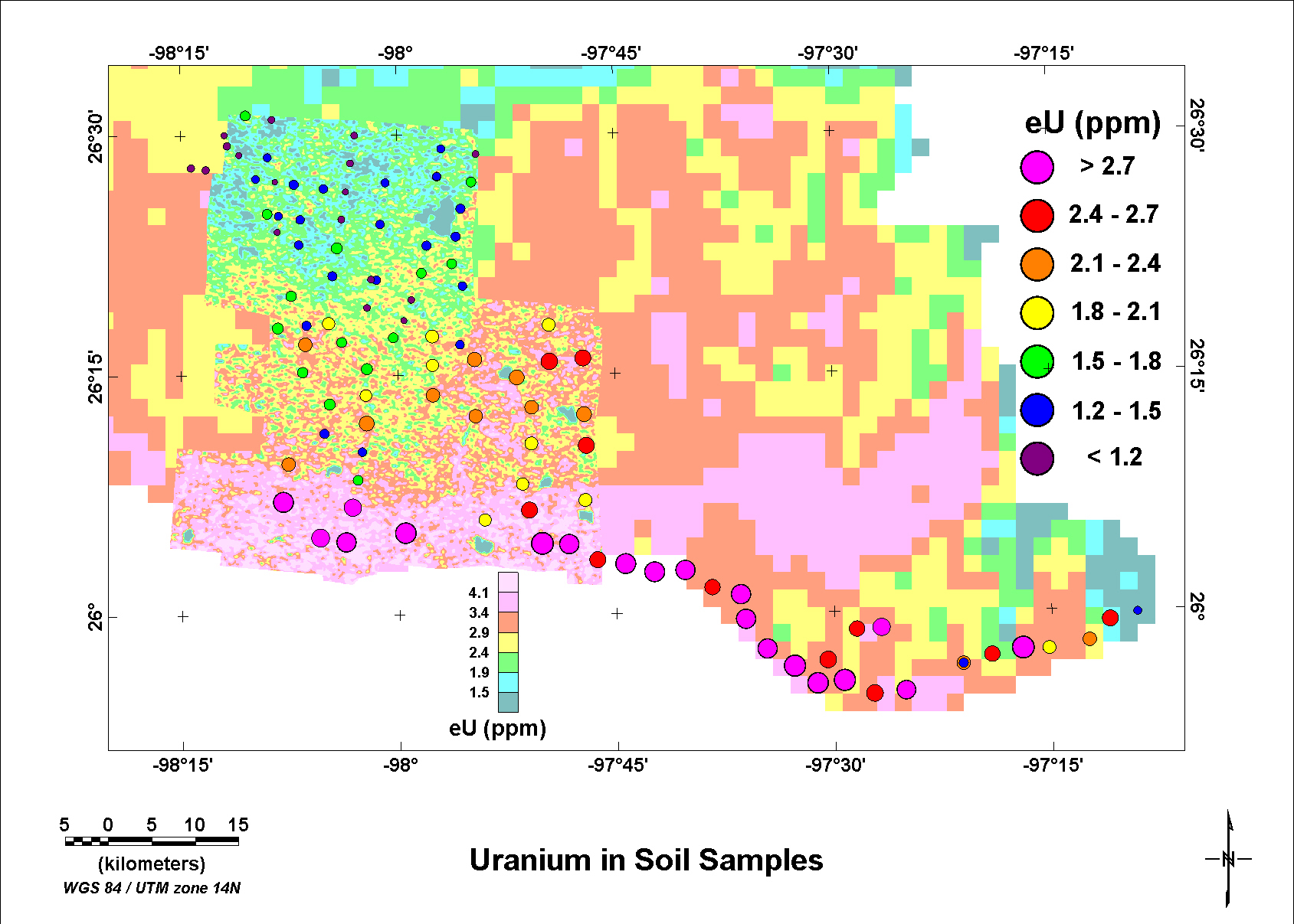
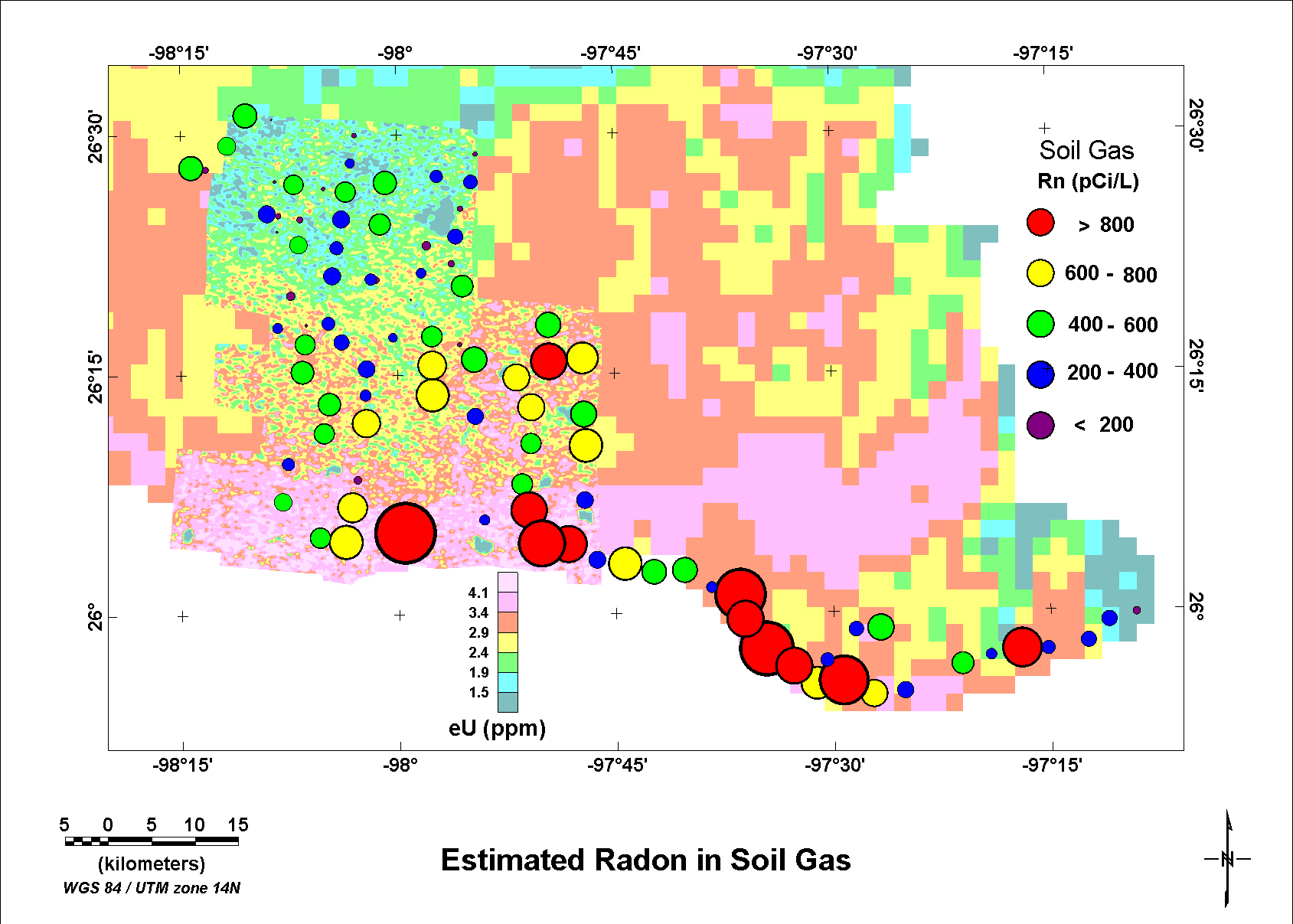
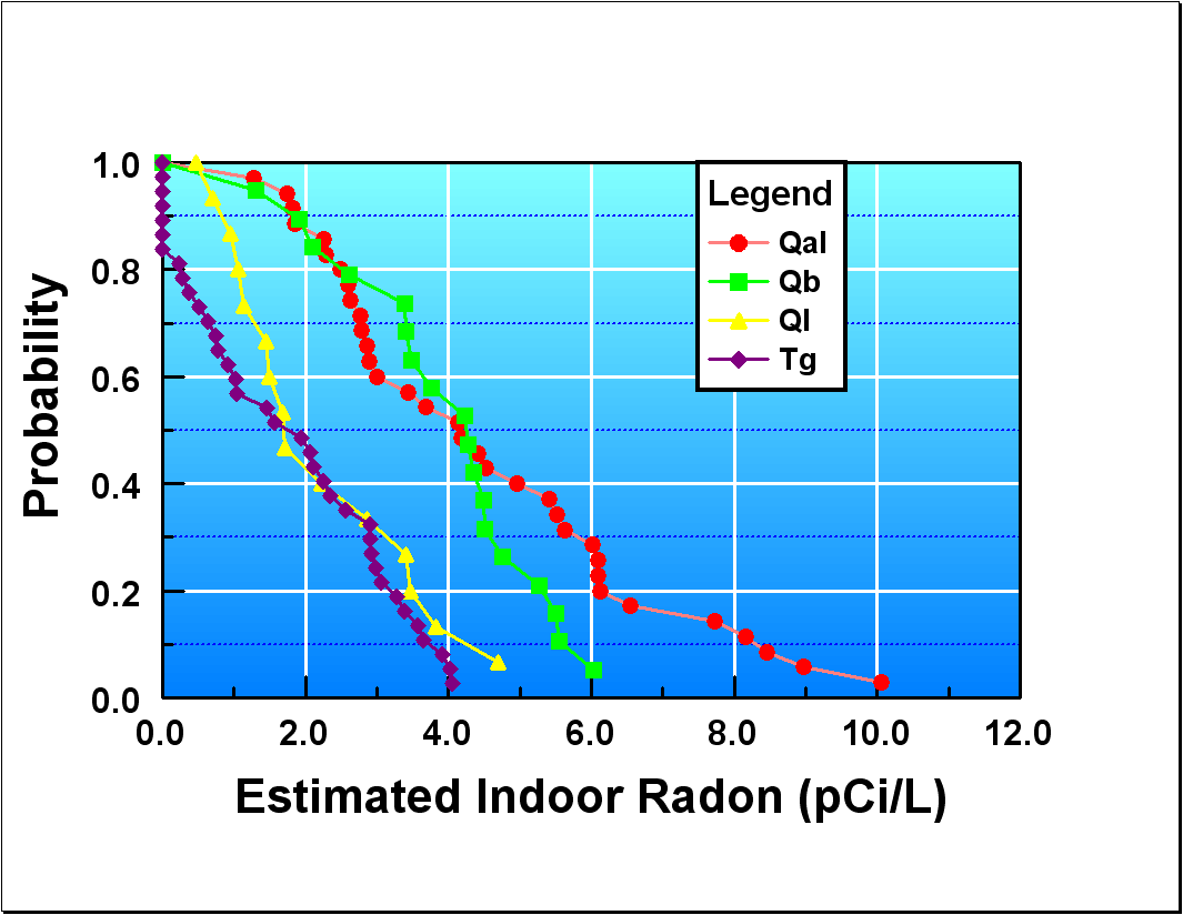
Sample Analysis ResultsA table listing the results of the analyses of the soil samples and derived parameters is available by clicking here. The column labeled Sample contains the sample identification consisting of ST for south Texas followed by the sample number assigned when the samples were collected. Column Class has numbers corresponding to the classes from the classification map of the aerial gamma-ray survey by Duval (2005). Column Clrev contains the interpretation of the classes as interpreted by Duval (2005. Column Density is the bulk dry density of the sample in units of g/cc. Column K is the potassium concentration in percent K. Column eU is the uranium concentration in parts per million (ppm) eU and eTh is the thorium concentration in ppm eTh. Rn Emanation is the estimate of the radon emanation fraction for the samples based upon the measurements described in the section on sample analysis. The column labeled Ra (pCi/g) is the radium concentration in units of picoCuries per gram. The Porosity was calculated from the bulk dry density assuming a grain density of 2.65 g/cc. Ra (Bq/m3) are the radium concentrations expressed as Becquerels per cubic meter. Soil Rn (Bq/m3) values are estimates of the radon concentrations in soil gas in units of Becquerels per cubic meter and Soil Rn (pCi/L) are the soil gas concentrations expressed as picoCuries per liter. The soil gas concentrations were calculated using the equation published by UNSCEAR (2000) (p. 98, Annex B). The column labeled Indoor Rn (pCi/L) has calculated values that assume 0.3 cubic meters of soil gas distributed in a room with dimensions of 4.6 m x 3.7 m x 2.4 m (15 ft x 12 ft x 8 ft). This estimate of possible indoor radon levels is based upon information published by Duval and others (2004) and assumes that the construction type is slab-on-grade. The columns Latitude and Longitude are the coordinates in degrees and defined on the NAD83 datum. The Sequence number is a number that can be used to reorder the rows. Figure 4 is a plot of the uranium concentrations as color coded circles indicating ranges of eU in ppm. All of the samples with values greater than 2.7 ppm eU are proximal to the Rio Grande and located within the Qal geologic unit. Figure 5 is a plot of the calculated estimates of soil gas concentrations. Figure 6 has graphs of the estimated indoor radon calculated using the assumptions stated above. The estimated values were grouped according to the classification variable Clrev as contained in the table of radiometric analyses of the samples revised as discussed in the section on discriminant analysis. Within each group the values were rank ordered and treated as probability distributions. Treating the data as representative samples of probability distributions provides a basis for estimating the likelihood of a particular concentration of indoor radon for homes located within the different geologic units. The resulting graphs suggest that materials classified as Goliad Formation (Tg) and Lissie Formation (Ql, includes areas mapped as sand dunes) have a probability less than 5 percent for indoor radon levels greater than 4 pCi/L. Materials classified as Holocene floodplain deposits (Qal) and Beaumont Formation (Qb) have indicated probabilities on the order of 50 percent for indoor radon levels greater than 4 pCi/L. The graphs also suggest that maximum indoor radon levels will be higher for the Holocene floodplain deposits than for the Beaumont Formation. The graphs of Figure 6 should be viewed as predictive tools that have not been validated.
Figure 4. Map with samples locations and equivalent uranium concentrations in parts per million. The colors of the circles indicate the range of values and the sizes of the circles are proportional to the values. The underlying map of uranium concentrations is from the grids of the aerial survey data from Duval (2005) and from Duval and Riggle (1999).
Figure 5. Map showing sample locations with estimated soil gas concentrations of radon. The colors of the circles indicate the range of values and the sizes of the circles are proportional to the values. The underlying map of uranium concentrations is from the grids of the aerial survey data from Duval (2005) and from Duval and Riggle (1999).
Figure 6. Probability curves of estimated indoor radon concentrations from groups of samples that were assigned to groups interpreted to represent geologic units. The groups used for these graphs are those that resulted from the discriminant analysis. |

![]() U.S. Department of the Interior |
U.S. Geological Survey
U.S. Department of the Interior |
U.S. Geological Survey
URL: http://
pubsdata.usgs.gov
/pubs/of/2005/1423/sotxsampdata.htm
Page Contact Information: USGS Publications Team
Page Last Modified: Saturday, 12-Jan-2013 21:49:28 EST