Skip past header information
USGS - science for a changing world
CZM logo with link to CZM home page

U.S. Geological Survey Open-File Report 2007-1373

High-Resolution Geologic Mapping of the Inner Continental Shelf: Cape Ann to Salisbury Beach, Massachusetts


Skip past contents informationTitle Page / Table of Contents / List of Figures / Introduction / Maps / Data Collection/Processing / Interpretation / Summary / Acknowledgments / References Cited / Appendix 1 / Appendix 2 / Appendix 3 / Appendix 4 / Appendix 5
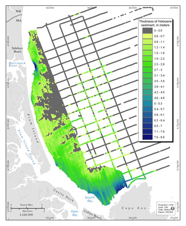

Figure 3.6. Map showing the thickness of sandy Holocene sediment (mobile sediment that overlies the transgressive unconformity).  Deposits thicker than 5 m are adjacent to the mouth of the Merrimack River and within Ipswich Bay.  Extensive areas offshore of central Plum Island and Salisbury Beach are covered by deposits thinner than 0.5 m.  Sediment-thickness values were interpreted from closely spaced seismic-reflection profiles.  In the nearshore area, measured values were used to generate an interpolated grid but, in the offshore area, the values are only displayed as discrete points along the widely spaced tracklines.


Figure 3.6.  Map showing the thickness of sandy Holocene sediment (mobile sediment that overlies the transgressive unconformity).  Deposits thicker than 5 m are adjacent to the mouth of the Merrimack River and within Ipswich Bay.  Extensive areas offshore of central Plum Island and Salisbury Beach are covered by deposits thinner than 0.5 m.  Sediment-thickness values were interpreted from closely spaced seismic-reflection profiles.  In the nearshore area, measured values were used to generate an interpolated grid but, in the offshore area, the values are only displayed as discrete points along the widely spaced tracklines.

Download the full size image in PDF format (2.6 MB).


Adobe Reader To view files in PDF format, download a free copy of Adobe Reader.


Skip USGS links group

Accessibility FOIA Privacy Policies and Notices

Take Pride in America logo USAGov logo U.S. Department of the Interior | U.S. Geological Survey
End of USGS links group