Skip past header information
USGS - science for a changing world
CZM logo with link to CZM home page

U.S. Geological Survey Open-File Report 2007-1373

High-Resolution Geologic Mapping of the Inner Continental Shelf: Cape Ann to Salisbury Beach, Massachusetts


Skip past contents informationTitle Page / Table of Contents / List of Figures / Introduction / Maps / Data Collection/Processing / Interpretation / Summary / Acknowledgments / References Cited / Appendix 1 / Appendix 2 / Appendix 3 / Appendix 4 / Appendix 5


Figure 4.1. Interpretive geologic map showing five physiographic zones on the inner continental shelf, including Ebb-Tidal Delta, Nearshore Ramp, Outer Basin, Rocky Zone, and Shelf Valley. Physiographic zones are superimposed on gray-scale, shaded-relief bathymetry except in areas adjacent to the shoreline in shallow water landward of the survey area. See Section 4 – Interpretive Geologic Mapping for a detailed description of each zone. Index boxes and profile lines show locations for other figures used in this report.


Figure 4.1.  Interpretive geologic map showing five physiographic zones on the inner continental shelf, including Ebb-Tidal Delta, Nearshore Ramp, Outer Basin, Rocky Zone, and Shelf Valley.  Physiographic zones are superimposed on gray-scale, shaded-relief bathymetry except in areas adjacent to the shoreline in shallow water landward of the survey area.  See Section 4 – Interpretive Geologic Mapping for a detailed description of each zone.  Index boxes and profile lines show locations for other figures used in this report.

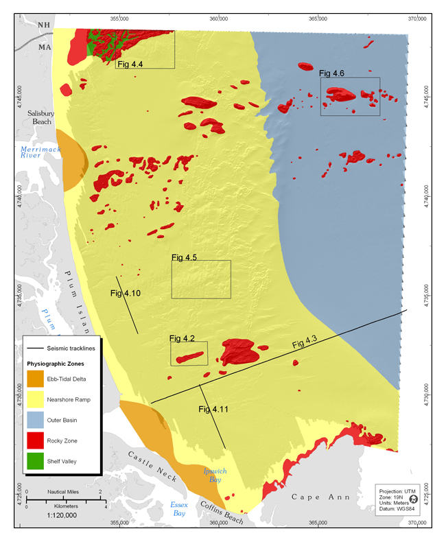
Download the full size image in PDF format (4.1 MB).


Adobe Reader To view files in PDF format, download a free copy of Adobe Reader.


Skip USGS links group

Accessibility FOIA Privacy Policies and Notices

Take Pride in America logo USAGov logo U.S. Department of the Interior | U.S. Geological Survey
End of USGS links group