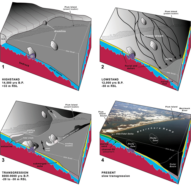
Figure 4.12. A four-phase conceptual model showing evolution of the northeastern Massachusetts coast and inner shelf as interpreted from geologic mapping. Schematic diagrams depict the general configuration of coastal landforms and stratigraphic units. Timing and elevation of relative sea level (RSL) are based on published reports and our best estimates. Each panel includes an outline of Plum Island in its present location. Phase 1: Late Pleistocene glaciers retreat across the isostatically depressed landscape, and leave behind drumlins and other till deposits. RSL is about 33 m higher than present. Thick glacial-marine sediment blankets high-relief bedrock. Phase 2: With crustal rebound, RSL falls to a lowstand of about –50 m depth. Braided streams flow across the emergent landscape and deposit a broad, relatively thin sheet of fluvial sand and gravel. A large delta forms at the lowstand shoreline about 10 km seaward of the present coast. Muddy marine sediment accumulates in deeper water. Phase 3: Early Holocene RSL rises to 20 to 30 m. Shoreline migration reworks the upper surface of the lowstand delta. Erosion produces a transgressive unconformity that is overlain by thin, discontinuous deposits of sandy marine sediment. A barrier island/spit, which is pinned to eroding drumlins, probably has formed seaward of Plum Island. Phase 4: RSL rise continues and the barrier/spit system migrates to its present location. Rocky Zone represents ledge or eroded remnants of drumlins. Nearshore Ramp represents the modified, gently sloping delta top. Ebb-Tidal Deltas form seaward of inlets. Channel-fill deposits are interpreted as estuarine sediment that accumulated in a back-barrier setting. Thick muddy sediment is preserved in the Outer Basin below the depth of RSL lowstand. (Photograph in panel 4 by Joseph Kelley, University of Maine, March 2005.)
Download the full size image in PDF format (6.8 MB).
 To view files in PDF format, download a free copy of Adobe Reader. To view files in PDF format, download a free copy of Adobe Reader.
|
 Title Page / Table of Contents / List of Figures / Introduction / Maps / Data Collection/Processing / Interpretation / Summary / Acknowledgments / References Cited / Appendix 1 / Appendix 2 / Appendix 3 / Appendix 4 / Appendix 5