U.S. Geological Survey Open-File Report 2008-1206
Coastal Change Along the Shore of Northeastern South Carolina: The South Carolina Coastal Erosion Study
Return to: Title and Abstract » Table of Contents » Section 1 » Section 2 » Section 3 » Section 4 » Section 5 » Section 6 » Acknowledgments » References » List of Figures » Acronymns » Glossary |
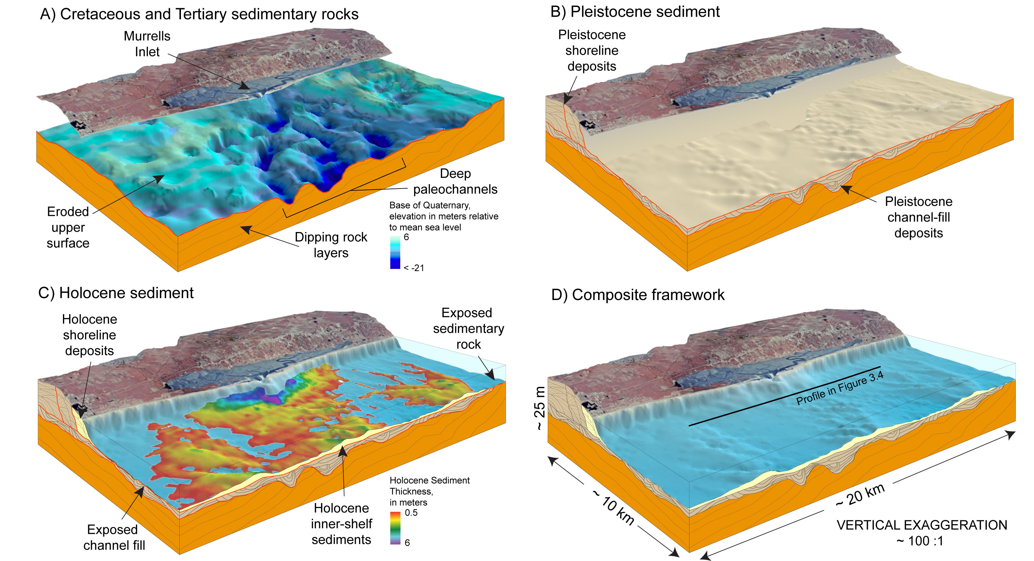
Figure 3.1. Schematic diagrams of the Murrells Inlet area showing the primary components of the Grand Strand geologic framework, from the deepest and oldest to the shallowest and youngest. See Figure 3.2 for the location of this area. A) Layered units of tilted Cretaceous and Tertiary sedimentary rocks underlie the entire coastal system. Relief on the surface of the rocks shows large channels deeply incised by rivers and streams at times of lower sea level. Elevations are shown relative to mean sea level (MSL). B) Pleistocene channel fills are regionally truncated by a low-relief erosional unconformity. Pleistocene shoreline deposits form the core of the coastal upland. C) Holocene shoreline and inner-shelf sediments overlie the regionally extensive erosional unconformity. Wedge-shaped shoreline deposits lie above and adjacent to the eroded remains of older Pleistocene shoreline deposits, and thin considerably across the shoreface onto the inner shelf. Rocks and channel fills are exposed at the seafloor over extensive areas lacking Holocene sediment cover. Deposits up to 6 m (20 ft) thick are primarily associated with tidal inlets. D) A composite view of the framework beneath the coastline and seafloor. Black line indicates the location of the seismic-reflection profile in Figure 3.4. Red lines in diagrams A-C indicate erosional unconformities. The onshore land image was compiled from 1999 digital-orthophoto quarter-quadrangles provided by the South Carolina Department of Natural Resources. <, deeper than; ~, about. [Click here for high-resolution image.]
 |

 U.S. Department of the Interior |
U.S. Geological Survey
U.S. Department of the Interior |
U.S. Geological Survey
URL: https://pubsdata.usgs.gov/pubs/of/2008/1206/html/figs/fig3_1.html
Page Contact Information: Publishing Service Center
Page Last Modified: Monday, 03-Jun-2019 11:36:33 EDT
