U.S. Geological Survey Open-File Report 2008-1206
Coastal Change Along the Shore of Northeastern South Carolina: The South Carolina Coastal Erosion Study
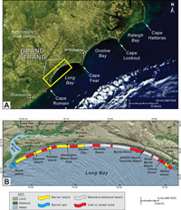
1.2 The Grand StrandPhysical Setting The nearly continuous series of sandy beaches in northeastern South Carolina is commonly known as the "Grand Strand". This arcuate segment of coast extends 100 km (62 mi) along the central and southern portions of Long Bay, a large embayment that lies between Cape Fear, North Carolina and Cape Romain, South Carolina (Figure 1.3). The broad, crescent-shaped shoreline is characteristic of regions where seasonal changes in wind directions produce waves that move sediment alternately up and down the coast. Waves are more important than tides in moving sediment along the Grand Strand, which has a low mean tidal range of 1.5 m (5 ft). These microtidal conditions typically result in narrow barrier islands that are separated by small tidal inlets (Hayes, 1994). Presently, beaches in the region receive little or no sediment from rivers. Sediment carried by the Pee Dee River, which discharges into Winyah Bay at the southern end of the Grand Strand, is trapped upstream behind dams or in the estuary before it reaches the coast (Patchineelam and others, 1999). Barrier islands and spits are limited to the northern and southern ends of the Grand Strand and are not present in the center (Figure 1.3). Waites Island, a small undeveloped barrier island near the North Carolina border, is separated from the mainland by a narrow estuary and salt marshes. The central part of the Grand Strand consists of mainland-attached beaches with residential and commercial development built close to the beach (Lennon and others, 1996). No tidal inlets are present in the stretch of coast between Cherry Grove and Garden City Beach; along this stretch beaches directly abut the mainland shore which reaches elevations as high as 11 m (36 ft) above local mean sea level. The character of the coast again changes in the southwestern part of Long Bay between Murrells Inlet and Winyah Bay, where short barrier islands and spits are separated from the mainland by narrow estuaries. This study focuses on terrestrial and marine environments in a swath that extends 5 to 15 km (3 to 9 mi) landward and 10 km (6 mi) seaward of the Grand Strand coastline. Inland, the study area includes the popular resort cities of Myrtle Beach, North Myrtle Beach, Surfside Beach, and several smaller coastal communities. Seaward, it covers the nearshore portion of the Long Bay inner continental shelf from the surf zone to water depths of about 15 m (50 ft). The low-relief seafloor slopes seaward at relatively steep gradients up to 4 m/km (21 ft/mi) in nearshore areas (Denny and others, 2007). Beyond the 7-m isobath, the slope decreases to 1 m/km (5.3 ft/mi) or less. Population, Economy, and Development The sandy beaches of the Grand Strand have attracted year-round residents and recreational visitors since the mid-1800s, when coastal development first began in the region. Since that time the Grand Strand has become increasingly popular as a tourist destination and as a home for many new residents. The population of Horry and Georgetown counties was recently estimated at almost 300,000 (U.S. Census Bureau, 2008). The number of year-round residents has grown 36.5 percent during the past decade (1990–2000) making it the 13th fastest growing metropolitan area in the nation. A robust tourism industry annually draws about 14 million visitors and generates over $2 billion in direct visitor expenditures (Myrtle Beach Area Chamber of Commerce, 2008). Tourism revenues produced along the Grand Strand account for more than 30 percent of the annual statewide total (2000–2004); this revenue represents an economic boon for the region as well as an important source of income for the State. A dramatic increase in residential, commercial, and infrastructure development (Figure 1.4) has accompanied this growth surge and has underscored the vulnerability of the Grand Strand to the perils of its coastal location. The continued economic success of the region and the quality of life that local residents enjoy are inherently tied to the integrity and quality of maintenance of local beaches. The beaches provide the recreational potential that drives the local tourism economy and, more importantly, protection from the impacts of storms and coastal erosion. With ongoing sea-level rise, beach erosion is expected to continue or possibly worsen, jeopardizing the future of the Grand Strand as a premier seaside resort. Next Section: 1.3 Coastal Hazards » |

 U.S. Department of the Interior |
U.S. Geological Survey
U.S. Department of the Interior |
U.S. Geological Survey
[an error occurred while processing this directive]
URL: https://pubsdata.usgs.gov
Page Contact Information: Publishing Service Center
Page Last Modified: Wednesday, 07-Dec-2016 21:39:02 EST