U.S. Geological Survey Open-File Report 2008-1206
Coastal Change Along the Shore of Northeastern South Carolina: The South Carolina Coastal Erosion Study
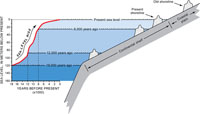
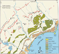
1.3 Coastal HazardsSea Level Global sea level has fluctuated widely due to climate changes and tectonic influences. Sea level falls during glacial periods, commonly referred to as Ice Ages, because large volumes of water evaporate from the oceans and become incorporated into ice sheets (see Box #1). The opposite occurs during interglacial periods such as today, when the climate is warmer and melting ice returns water to the oceans. Warmer ocean water also expands, causing additional sea-level rise. In response to these changes in sea level, coastal systems have migrated across the continental shelf and coastal plain of South Carolina (Figure 1.5). These landscapes are flat and gently sloping, so a small rise in sea level can inundate a broad area of land. The shoreline moves landward as sea level rises. When sea level reaches its maximum elevation, movement of the shoreline slows to a stop. Sediment has more time to accumulate while the coast remains in one position, so barrier islands and other shoreline deposits develop and grow. The Atlantic Ocean has flooded nearly all of the South Carolina coastal plain during the geologic past due to repeated cycles of sea-level rise and fall. The generally flat coastal plain steps down toward the ocean in a series of terraces that are aligned northeast-southwest, roughly parallel to the Grand Strand coast. The terraces are separated by erosional escarpments and low linear hills that represent ancient shorelines (Figure 1.6). The shoreline features formed at times of high sea level over the last 3-4 million years. The Orangeburg Scarp is the oldest shoreline and lies more than 100 km (62 mi) landward of Myrtle Beach. It was formed by wave erosion when the coast was located west of the cities of Florence and Sumter. These erosional scarps and shoreline deposits progressively decrease in age and elevation towards the modern coast (DuBar and others, 1974; Colquhoun and others, 1991), where a new escarpment is currently forming along the Grand Strand. Although these ancient shoreline features are indicative of sea-level changes in the distant past, the record that they provide is largely incomplete. Old shorelines also formed seaward of the modern coast when sea level was lower than present, but most evidence has been eroded away by ocean processes. Sea level has slowly continued to rise over the course of our lifetimes. Tide-gauge records from around the world indicate that global sea level increased at an average rate of about 2 mm/yr (0.7 ft/century) during the 19th and 20th centuries (Douglas, 1997). Long-term records from Charleston show that the rate of sea-level rise is considerably higher along the South Carolina coastline, where it is estimated at 3.28 mm/yr (1.08 ft/century). As sea level slowly continues to rise, low-lying coastal areas will be inundated, and the beaches, barriers, and marshes of the Grand Strand coastal system will continue to migrate landward. Waves and currents will erode and redistribute sediment from older deposits along the coast, providing much needed "new" sediment to nourish the modern beaches of the Grand Strand. Storms Tropical cyclones (tropical storms and hurricanes) and northeasters represent the greatest natural hazard facing South Carolina coastal communities. These severe storms generate strong winds and waves, heavy rainfall, and storm surge, which cause extensive erosion, flooding, and damage to infrastructure and development. If storms move slowly, or stall at a single location, they might batter a stretch of coastline for several days and wreak great destruction. Historically, South Carolina has experienced direct landfalls of tropical storms and hurricanes relatively infrequently, averaging one every four to five years (see Box #2). Since 1871, 33 tropical storms and hurricanes have directly hit the state (SCDNR-SCO, 2007). Northeasters, informally called "Nor'easters," are winter storms that affect the South Carolina coastline every year with strong winds that blow in a northeast to southwest direction. These storms can be ten times larger than a hurricane and thereby affect a broader stretch of coast at one time. Strong winds associated with storms accentuate high tides by piling ocean water along the coast and not allowing it to recede during a subsequent low tide. If this situation persists over multiple tidal cycles, extreme coastal flooding results. Such storms do not need to make direct landfall in order to significantly affect the coastline. Whether they make landfall elsewhere and pass through the state or pass close to the coast offshore, they can still produce violent winds, waves, and storm surge. Storms that pass farther offshore might actually be beneficial by generating long-period swells that move sandy sediment towards Grand Strand beaches. Next Section: 1.4 Beachfront Management » |

 U.S. Department of the Interior |
U.S. Geological Survey
U.S. Department of the Interior |
U.S. Geological Survey
URL: https://pubsdata.usgs.gov/pubs/of/2008/1206/html/implications3.html
Page Contact Information: Publishing Service Center
Page Last Modified: Monday, 03-Jun-2019 11:36:39 EDT