U.S. Geological Survey Open-File Report 2008-1206
Coastal Change Along the Shore of Northeastern South Carolina: The South Carolina Coastal Erosion Study
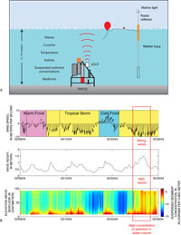
2.4 Mapping Sediment MovementIn order to fully understand how sediment moves within the coastal system, scientists placed numerous oceanographic instruments on the shallow seafloor offshore of the Grand Strand beaches. Current meters, sediment traps, wave-height sensors, and other instruments were attached to sturdy metal frames (tripods) and anchored to the seafloor (Figure 2.11). At regular intervals over a six-month period, these tripods collected time-series measurements of water flow, sea level, seafloor bedforms (ripples), near-bottom turbulence, suspended sediment concentrations, salinity and temperature (Sullivan and others, 2005). Supplemental data such as wind speed and direction, air temperature, barometric pressure, and streamflow measurements were also collected. 2.5 SummaryA suite of high-resolution remote-sensing and sampling techniques were used to define the geologic framework, assess historic shoreline change, and identify oceanographic processes influencing sediment transport along the Grand Strand. The geologic framework forms the foundation of the coastal system and reveals seafloor topography, distribution of rocks and sediment on the seafloor, and structure and composition of underlying geology. Historical shoreline analysis allows monitoring of short- and long-term trends in shoreline change. Knowledge of the geologic framework and shoreline change is used to site oceanographic studies that measure winds, waves and currents. This multi phase approach helps to better understand the mechanisms influencing coastal change along the Grand Strand. Next Section: SECTION 3. Geologic Framework » |

 U.S. Department of the Interior |
U.S. Geological Survey
U.S. Department of the Interior |
U.S. Geological Survey
[an error occurred while processing this directive]
URL: https://pubsdata.usgs.gov
Page Contact Information: Publishing Service Center
Page Last Modified: Wednesday, 07-Dec-2016 21:39:05 EST