U.S. Geological Survey Open-File Report 2009-1042
National Assessment of Historical Shoreline Change: A Pilot Study of Historical Coastal Bluff Retreat in the Great Lakes, Erie, Pennsylvania
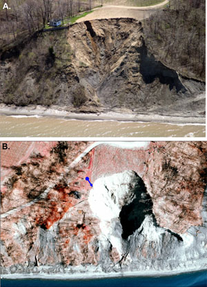
In 1974, the Coastal Resources Management Program (CRM) of the Pennsylvania Department of Environmental Protection (PA DEP) undertook an inventory of shore hazards, including coastal flooding and bluff recession. This study (Knuth and Crowe, 1975) was intended to determine the degree to which shoreline erosion and bluff retreat were occurring in Erie County. The study also justified the creation of structural setbacks. The Commonwealth of Pennsylvania passed the Bluff Recession and Setback Act in 1980. Included in the terms of the Act was a stipulation that required CRM to continue to monitor and update recession rates, with new recession studies to be undertaken periodically. Pennsylvania, in accordance with the requirements of the Bluff Recession and Setback Act, has monitored its recession rates at least once every 4 years since 1982. Initial bluff-monitoring control points were established in 1982, with additional control points added in 1985 and 2002. Bluff-recession measurements at 125 fixed control point monuments were made in 1982-83, 1986-87, 1989-90, 1994-95, 1998-99, 2002-03, and 2006-07. Long-term (25-year) average retreat rates as high as 1.0 m/yr at specific control-point locations and bluff recession up to 11.3 m between monitoring cycles have been documented as part of the monitoring program. Some control points are in stable bluff areas and show no measurable recession. Although the long-term average recession rate based on all the control points for the Lake Erie Coastal Zone is 0.23 m/yr, recession tends to be spatially variable and temporally episodic. Additionally, the control-point measurement sites were chosen independently of known erosion hazard areas; therefore, in some cases, very low retreat rates were measured as part of the study when rates in immediately adjacent areas were much higher. The location of a control point at which the long-term recession rate is 0.04 m/yr is shown in figure 1. The control-point location does not accurately reflect the high rates of retreat and high hazard in the area. In contrast, a long-term recession rate of 1.0 m/yr was documented at an adjacent control point (fig. 2), located in what was found to be a rapidly receding stretch of coastline. Because the control points are randomly located with respect to coastal processes, recession hazard is adequately monitored at some locations but not at others. The Pennsylvania monitoring effort has generated highly accurate bluff-retreat data and a robust temporal database. Because the field measurement effort is labor intensive, the resulting spatial density of control points (approximately 0.5 km apart) may not adequately capture the greatest erosion hazards. In 1994, the U.S. Army Corps of Engineers (USACE) published a report describing available bluff retreat data and assessments that existed for all of the Great Lakes coastlines, including methods used and data accuracy. According to this report (Stewart, 1994), earlier assessments of bluff retreat were undertaken in the mid 1970s by using aerial photographs from 1938/39-1975 (Knuth and Crowe, 1975) and photogrammetric methods to determine a long-term rate of bluff retreat for a 36-year period. The 1994 USACE report was intended to present prior methods of determining bluff retreat, not to provide new data. Although numerous analyses of bluff retreat have been conducted throughout the coastal United States including the Great Lakes, a critical need remains for (1) a nationwide compilation of reliable retreat data that includes a modern bluff-edge position and (2) a standardization of methods for compiling and comparing cliff positions and mathematically analyzing the trends. |

![]() U.S. Department of the Interior |
U.S. Geological Survey
U.S. Department of the Interior |
U.S. Geological Survey
[an error occurred while processing this directive]
URL: https://pubsdata.usgs.gov
Page Contact Information: Contact USGS
Page Last Modified: Wednesday, 07-Dec-2016 21:51:34 EST