U.S. Geological Survey Open-File Report 2009-1101
The Partition Intervalometer: A Programmable Underwater Timer for Marking Accumulated Sediment Profiles Collected in Anderson Sediment Traps: Development, Operation, Testing Procedures, and Field Results
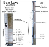
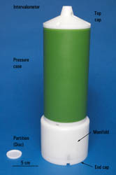
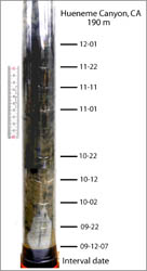
The originally designed Intervalometer included programmable instrumentation that deposited Teflon granules at timed intervals onto the surface of the sediment collected throughout the deployment period (Anderson, 1977). The resulting sediment profile was stratigraphically separated by a succession of unique Teflon layers that were deposited on a time-series basis (fig. 3). Under certain conditions, such as a low rate of sedimentation, high water content in the material in the collection tube or tilting of the trap from a vertical orientation, the granules tended to migrate or shift position within the sediments of the collection tube. This condition made interpretation and sampling difficult. The Partition Intervalometer was subsequently redesigned by Roger Anderson to dispense hydrodynamically shaped Teflon discs (fig. 4). When released from the supply manifold, the disc vertically descends through the water in the trap and into the collection tube and settles upon the surface of sediment (fig. 5). This advance permits improved sampling procedures and interpretation of the sedimentary profile by more accurately defining unique sediment intervals throughout the sediment column. Members of the USGS technical staff from the Woods Hole Science Center and Roger Anderson have entered into a joint agreement to provide, fabricate, and test prototype state-of-the-art instrumentation. Under this agreement, Anderson has provided the initial design specifications for the Partition Intervalometer, and the USGS has supplied materials, fabricated several units, furnished the necessary design modifications, and developed testing protocols for a prototype and several upgraded field versions of the instrumentation. |

![]() U.S. Department of the Interior |
U.S. Geological Survey
U.S. Department of the Interior |
U.S. Geological Survey
URL: https://pubsdata.usgs.gov/pubs/of/2009/1101/html/development.html
Page Contact Information: Contact USGS
Page Last Modified: Wednesday, 07-Dec-2016 21:54:50 EST