U.S. Geological Survey Open-File Report 2009-1101
The Partition Intervalometer: A Programmable Underwater Timer for Marking Accumulated Sediment Profiles Collected in Anderson Sediment Traps: Development, Operation, Testing Procedures, and Field Results
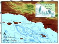
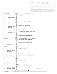
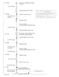
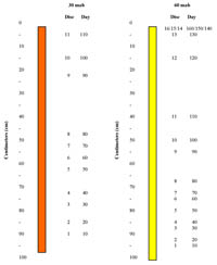
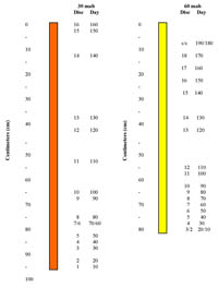
After the laboratory and pressure-testing programs and the necessary modifications were completed, the Intervalometers were deployed off the coast of Southern California by members of the USGS Marine Science Teams from Woods Hole, Massachusetts, and Santa Cruz, California. Anderson sediment traps with a 0.25-m²-area opening (an approximately10-inch collection diameter) and an Intervalometer internally attached were vertically mounted on bottom-resting tethered moorings at the heads of Hueneme and Mugu Canyons off the coast of Southern California (fig. 11). Sediments were collected in a clear polycarbonate tube measuring 5.72 cm outer diameter x 5.1 cm inner diameter x 99 cm long (2.25"x 2.00"x 39") with an extrusion piston inserted in the bottom of the tube. The collection tube was placed inside a protective PVC tube, which was screwed into the bottom of the sediment trap. Upon recovery, the sediments were sub-sampled for various geochemical constituents (such as DDT) and grain size and further examined to determine rates of sedimentation. These data will be utilized as part of an overall effort to determine the transport and fate of contaminated sediments along the Southern California Continental Shelf, particularly regarding the influence of submarine canyons upon regional longshore sediment transport. Two subsurface moorings, each approximately 122 m (400 ft) in length, were deployed at the Mugu Canyon and Hueneme Canyon sites on September 12, 2007. Both moorings were successfully recovered on April 3, 2008, aboard the R/V Sproul. Hueneme Canyon Site (mooring 838) The mooring deployed at the Hueneme Canyon site (at a water depth of approximately 190 m (623 ft)) included several types of oceanographic instruments used to collect and log current and turbidity data as well as two sediment traps and associated Intervalometers that were all attached to the mooring line. The traps were approximately 60 m and 30 m above the bottom (mab) of the sea floor (fig. 12). The upper trap at a depth of 60 m contained Intervalometer 4. It was programmed for a 10-day disc-drop interval and preset at 09:30 local time on September 11, 2007, at the Scripps Institute for Marine Oceanography’s Marine Facility. The magazine was loaded with 18 sequentially numbered discs plus 2 overlying stainless steel washers as added weight upon the partitions. A similar stacking protocol for the discs and the stainless steel washers was also prepared for the remaining Intervalometers. The lower trap, which contained Intervalometer 5, was also set for a drop-time interval of 10 days and initialized at 10:05 on the same day. Mugu Canyon Site (mooring 839) Three sediment traps and internally attached Intervalometers were also deployed at the Mugu Canyon site (at a water depth of approximately 190 m (623 ft)). The traps were attached to the mooring line at depths of approximately 30, 60 and 100 mab (fig. 13). The traps were also initialized on the same date as the traps for the Hueneme Canyon site. The 100-mab trap contained Intervalometer 1 and was initialized at 08:56 local time; the 60-mab trap with Intervalometer 2 was programmed at 09:10; and Intervalometer 3, placed in the deeper trap at 30 mab, was preset at 09:42 am. ResultsHueneme Canyon–Collection tube at 60 mab The sediments collected from the shallower 60-mab trap overfilled the tube and partially filled the base of the sediment trap cone. All discs and washers were released from the Intervalometer, and 16 discs were deposited throughout the entire length of the collection tube (fig.14). The remaining two discs and washers were in the sediment deposited above the collection tube. Slightly more than 160 days of sediment accumulated in the collection tube as determined by the 16 consecutively numbered discs deposited at 10-day intervals. The sediments in the collection tube were primarily muddy in nature. Alternating black-band coloration throughout the 70- to 80-cm section of the core was evident. Anoxic conditions in the 80- to 90-cm interval were evidenced by a hydrogen sulfide (rotten-egg) smell emanating from the sediments. Hueneme Canyon–Collection tube at 30 mab Similarly to the collection tube at 60 mab, the sediments from this trap had filled the collection tube and overflowed into the base of the sediment-trap cone. Eleven discs distributed throughout the length of the tube indicated approximately 110 days of accumulated sediment (fig. 14). Several of the discs were slightly tilted and resting at an acute angle in several areas of the sediments. This tilt may have resulted from surface irregularities of the previously deposited sediment, disturbance of the mooring, high water content, or the irregular falling motion of a disc as it was released from the drop hole of the Intervalometer. The remaining discs and washers were in the overfilled sediment above the collection tube. Several discs were also positioned in the storage manifold because of an apparent rotor-assembly malfunction. The muddy sediments revealed alternating linear bands of black discoloration at the 15- to 16-cm and 35- to 41-cm intervals. Stratigraphic variations of sediment-grain size were also evident with alternating coarse and fining sequences at the 41- to 48-cm interval and a distinctly coarser grained layer at the 74- to 76-cm interval. The magnitude of the sediment thickness in both collection tubes was similar early in the deployment period at the 40- to 50-day interval (6 and 8 cm, respectively); however, approximately 50 percent more sediment by volume was collected in the lower trap during the 80- to 90-day time period than in the upper trap (26 and 17 cm, respectively). Overall, the lower sediment trap (at 30 mab) filled with sediment in just over 110 days and collected 40 percent more material by volume than the shallower trap at 60 mab, which filled with sediment in slightly more than 160 days. Mugu Canyon–Collection tube at 100 mab Only 2.5 cm of sediment accumulated in the collection tube of the shallowest sediment trap at approximately 100 mab. However, over 30 percent of the sediment-trap cone above the collection tube was filled with sediment; sediment had collected in the trap but was blocked from entering the collection tube. Upon further examination, it was determined that the diameter of the first disc discharged by the Intervalometer was larger than the diameter of the sediment-trap funnel opening where the funnel attaches below to the collection tube. Consequently, that first disc obstructed the opening and prevented any additional sediment from passing into the collection tube. All the discs and washers were released from the Intervalometer and situated throughout the overlying sediment in the lower area of the sediment-trap cone. Unfortunately, the discs were scattered throughout the sediment in a random manner within the large area of the cone so that it was virtually impossible to follow the sampling protocol and to obtain a meaningful stratigraphic correlation. Mugu Canyon–Collection tube at 60 mab The full complement of discs and the two washers were also released from the Intervalometer of the middepth trap at 60 mab (fig. 15). There was no evidence of overfilling of sediment into the sediment-trap cone. When the sediment was extruded from the collection tube, however, the first disc was not evident. It may not have been loaded into the manifold or may have been lost at sea during the transfer procedure. On the basis of these results, it appeared that 190 days of sediment had accumulated below the last washer with an additional 9 cm of sediment deposited above this last marker. The muddy sediment displayed linear bands of black coloration in the upper layers of the core at the 8- to 11-cm and 21- to 22-cm intervals. Mugu Canyon–Collection tube at 30 mab This collection tube was also over filled with sediment. The first disc was overlying approximately 3 cm of sediment near the bottom of the tube. The remaining 15 labeled discs were sequentially deposited above the first disc throughout the entire length of the core tube. A total sediment accumulation period of approximately 160 days elapsed before release of the sixteenth disc with approximately 2 cm of additional sediment overlying the sixteenth disc (fig. 15). The two washers and disc 18 were deposited in the sediment that overfilled the bottom of the sediment-trap cone. Disc 17 was not found and may have been lost in the transfer at sea or during the sampling procedure. Extensive black-banding coloration was also apparent throughout the length of the core’s muddy sediment from 40- to 90-cm with slightly coarser areas evident at the 18- to 34-cm and 46- to 53-cm intervals. Comparisons of the collection tubes from the middepth trap and lower trap indicate a similar sediment thickness of approximately 4 cm collected at the 40- to 50-day interval. However, the amount of sediment collected in the lower trap increased over time at the 80- to 90-day and 130- to 140-day intervals to 8.5 cm and 26.5 cm, respectively. The middepth trap exhibited sediment thicknesses of 2 cm and 11 cm for these same time periods. The lower tube (30 mab) filled with sediment in just over 160 days and collected approximately 60 percent more material by volume than the collection tube from the middepth trap (60 mab) over the comparable time period. |

![]() U.S. Department of the Interior |
U.S. Geological Survey
U.S. Department of the Interior |
U.S. Geological Survey
URL: https://pubsdata.usgs.gov/pubs/of/2009/1101/html/results.html
Page Contact Information: Contact USGS
Page Last Modified: Wednesday, 07-Dec-2016 21:55:01 EST