U.S. Geological Survey Open-File Report 2009-1101
The Partition Intervalometer: A Programmable Underwater Timer for Marking Accumulated Sediment Profiles Collected in Anderson Sediment Traps: Development, Operation, Testing Procedures, and Field Results
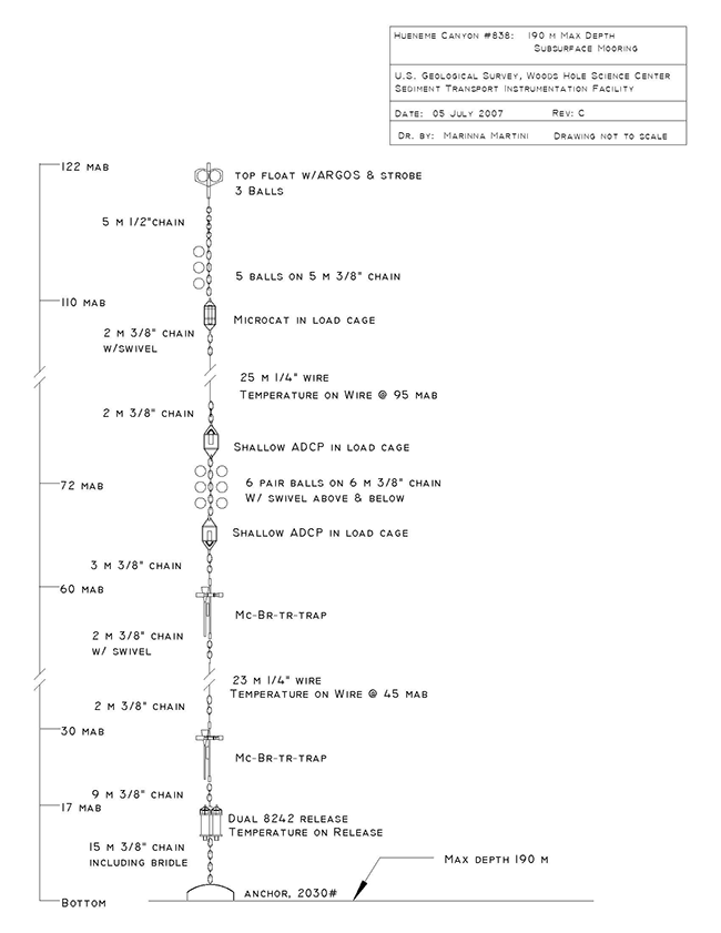
Figure 12. Subsurface mooring diagram for the Hueneme Canyon site (mooring 838). The mooring was deployed at approximately 190-m water depth and is approximately 122 m in length. The two sediment traps are at 30 mab and 60 mab. The drawing is not to scale. Abbreviations on the diagram signify additional oceanographic instrumentation attached to the mooring line: ADCP-acoustic Doppler current profiler; Mc-Microcat conductivity/temperature recorder, Br-Brancker multichannel data recorder, Tr-transmissometer/turbidity sensor, Trap-Anderson sediment trap. [Download the full size image in PDF format, 36 KB.] |
 |
To view files in PDF format, download free copy of Adobe Reader

![]() U.S. Department of the Interior |
U.S. Geological Survey
U.S. Department of the Interior |
U.S. Geological Survey
URL: https://pubsdata.usgs.gov/pubs/of/2009/1101/html/figure12.html
Page Contact Information: Contact USGS
Page Last Modified: Wednesday, 07-Dec-2016 21:54:52 EST
