U.S. Geological Survey Open-File Report 2009-1137
Quaternary Geologic Framework of the St. Clair River between Michigan and Ontario, Canada
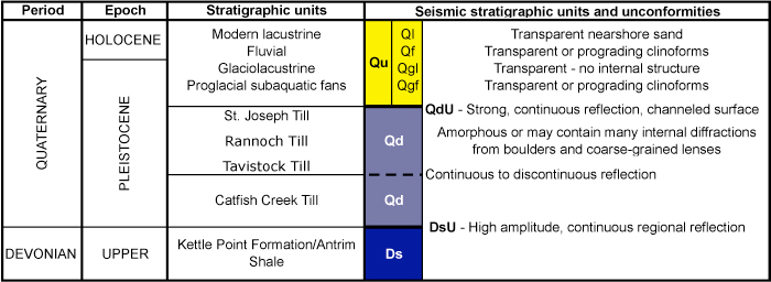
Table 1. Stratigraphic column for the northernmost St. Clair River area (Morris, 2008), with correlations to seismic stratigraphic units Devonian shale (Ds), Quaternary glacial drift (Qd), and Quaternary undifferentiated (Qu). Qu includes glaciofluvial, glaciolacustrine, fluvial, and lacustrine deposits. Major unconformities are the top of Devonian shale (DsU) and the top of glacial drift (QdU). |
 |

![]() U.S. Department of the Interior |
U.S. Geological Survey
U.S. Department of the Interior |
U.S. Geological Survey
URL: https://pubsdata.usgs.gov/pubs/of/2009/1137/html/table1.html
Page Contact Information: Contact USGS
Page Last Modified: Wednesday, 07-Dec-2016 21:58:34 EST
