U.S. Geological Survey Open-File Report 2010–1007
Sea-Floor Geology and Character Offshore of Rocky Point, New York
 |
||
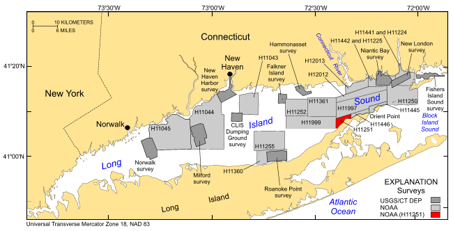
Figure 1. Location of the bathymetric and backscatter surveys completed in Long Island Sound. Surveys by the NOAA ships Thomas Jefferson and Rude are shown in light gray and include H11043—Poppe and others (2004, 2006a); H11044—McMullen and others (2005); and H11045—Beaulieu and others (2005); H11255—Poppe and others (2006c); H11250—Poppe and others (2006b, 2007a); H11252/H11361—Poppe and others (2007b, 2008); H11441/H11442/H11224/H11225—Poppe and others (2010); H11445—McMullen and others (2010). Sites of USGS sidescan-sonar surveys are shown in dark gray and include Norwalk—Twichell and others (1997); Milford—Twichell and others (1998); New Haven Harbor and New Haven Dumping Grounds—Poppe and others (2001); Roanoke Point—Poppe and others (1999a); Falkner Island—Poppe and others (1999b); Hammonasset—Poppe and others (1997); Niantic Bay—Poppe and others (1998c); New London—Lewis and others (1998), Zajac and others (2000, 2003); Fishers Island Sound—Poppe and others (1998b). Click here for a larger version of image. | ||

![]() U.S. Department of the Interior |
U.S. Geological Survey
U.S. Department of the Interior |
U.S. Geological Survey
URL: https://pubsdata.usgs.gov/pubs/of/2010/1007/html/fig1.html
Page Contact Information: Contact USGS
Page Last Modified: Wednesday, 07-Dec-2016 22:38:02 EST


