U.S. Geological Survey Open-File Report 2010–1007
Sea-Floor Geology and Character Offshore of Rocky Point, New York
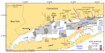
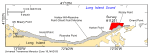
The U.S. Geological Survey (USGS), in cooperation with National Oceanic and Atmospheric Administration (NOAA) and the Connecticut Department of Environmental Protection (CT DEP), is producing detailed maps of the sea floor in Long Island Sound (fig. 1). The current phase of this cooperative research program is directed toward studies of sea-floor topography and its effect on the distributions of sedimentary environments and benthic communities. Because anthropogenic wastes, toxic chemicals, and changes in land-use patterns resulting from residential, commercial, and recreational development have stressed the environment of the sound and caused degradation and potential loss of benthic habitats (Koppelman and others, 1976; Long Island Sound Study, 1994), detailed maps and interpretations of the sea floor are needed to evaluate the extent of adverse impacts and to manage resources wisely in the future. The purpose of this report is to release the imagery, digital terrain models (DTMs), interpretive data layers, and data derived from sidescan-sonar and multibeam echo-sounder data collected offshore of Rocky Point, New York, in eastern Long Island Sound, and from the 19 stations occupied to verify these acoustic data (fig. 2). Basic data layers include backscatter intensity and grids and sun-illuminated imagery of sea-floor topography; an interpretive layer shows the distribution of geologic features on the sea floor. Presented supplemental and verification data include sediment grain-size analyses and a gallery of still photographs of the seabed. These bathymetric datasets serve many purposes, including (1) defining the topographic variability of the sea floor, which is one of the primary controls of benthic habitat diversity; (2) improving our understanding of the oceanographic processes that control the distribution and transport of bottom sediments and the distribution of benthic habitats and associated infaunal community structures; and (3) providing a detailed framework for future research, monitoring, and management activities. These datasets also serve as base maps for subsequent sedimentological, geochemical, and biological observations, because precise information on topography and environmental setting is important for the selection of sampling sites and for accurate extrapolation and interpretation of point measurements. |

![]() U.S. Department of the Interior |
U.S. Geological Survey
U.S. Department of the Interior |
U.S. Geological Survey
URL: https://pubsdata.usgs.gov/pubs/of/2010/1007/html/intro.html
Page Contact Information: Contact USGS
Page Last Modified: Wednesday, 07-Dec-2016 22:38:22 EST