U.S. Geological Survey Open-File Report 2010–1007
Sea-Floor Geology and Character Offshore of Rocky Point, New York
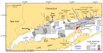
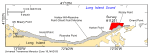
Glacial processes during the northward retreat of the late Wisconsinan Laurentide ice sheet about 18 to 19.5 thousand years ago (ka) produced the Harbor Hill-Roanoke Point-Orient Point moraine that approximately parallels the northern shore of Long Island, New York (figs. 1, 2; Schafer and Hartshorn, 1965; Sirkin, 1982). In addition, the retreat formed Glacial Lake Connecticut when the last ice front began to recede from the moraine position and meltwater was impounded in the expanding, long, narrow basin between the moraine and the retreating ice margin (Flint and Gebert, 1976; Stone and Borns, 1986; Lewis and DiGiacomo-Cohen, 2000). Various deltaic and varved deposits of this lake, which occupied most of the present Long Island Sound basin, overlie the glacial drift (Stone and others, 2005). The glacial drift and glaciolacustrine deposits all are truncated by a marine unconformity. This unconformity is a composite product of the subaerial exposure of these sediments (which occurred after glacial Lake Connecticut drained) and the succeeding marine transgression that occurred after 15 ka (Lewis and DiGiacomo-Cohen, 2000). A Holocene marine mud facies is present in deeper, quiet-water areas throughout the western and central parts of the Long Island Sound basin and records deposition during the postglacial eustatic rise of sea level (Lewis and DiGiacomo-Cohen, 2000). The northern shoreline of Long Island east of Port Jefferson (fig. 2) is classified as a glacial deposition coast (Shepard, 1963) because it coincides with the eroded and partially submerged sections of the Harbor Hill-Roanoke Point-Orient Point moraine. This section of the shoreline is characterized by high, steep bluffs (as much as 40 m relief), gently curved beaches separated by headlands that project slightly into the sound, and cape-associated shoals (Koppelman and others, 1976; U.S. Army Corps of Engineers, 1969). The bluffs on Long Island's north shore are only partly covered by vegetation and are fronted by narrow beaches, and the adjacent beaches average about 12 m wide (Davies and others, 1973). Both the beaches and bluffs are eroding rapidly; average annual shoreline retreat is about 0.8 m/year (Bokuniewicz and Tanski, 1983). As the bluffs recede, eroded sediments accumulate as talus on the narrow beaches. Wave attack during storms removes much of the talus and erodes the bluffs. Boulders and coarse gravel remain on the beach as lag deposits; the finer grained sediments are winnowed into the sound. The mean-high-water line migrates landward as the beach deposits are removed, and the cycle of bluff and beach erosion continues. The main current regimes controlling sedimentary processes along the northern shoreline of Long Island east of Port Jefferson are a wind- and wave-driven regime that predominates nearshore and a tidal regime that predominates offshore. Normal circulation in the sound and prevailing westerly winds combine to set up an eastward longshore littoral drift, as indicated by beach accretion on the west or up-drift side of jetties, groins, and other obstructions and by erosion on the sediment-starved east or down-drift side (Omholt, 1974; Signell and others, 2000). The littoral sediments are transported eastward along the coast to headlands where they are deflected offshore. Along the western part of this section of the coast, sands accumulate in and sustain a series of shore-connected, cape-associated shoals, such as those off Mount Misery, Herod, and Roanoke Points, and only the muddy sediments (for example, silts and clays) are moved farther offshore to lower energy environments (Knebel and Poppe, 2000). However, tidal-current speeds increase dramatically east of Roanoke Point toward Orient Point. For example, tidal currents are stronger during flood tides just off the tip of Roanoke Point, where they can exceed 30 cm/s, but are strongest during ebb tides just northeast of Rocky Point, where they can exceed 189 cm/s (Signell and others, 2000; White and White, 2009). These elevated current speeds promote sedimentary environments characterized by erosion and nondeposition and prevent the formation of well developed cape-associated shoals. |

![]() U.S. Department of the Interior |
U.S. Geological Survey
U.S. Department of the Interior |
U.S. Geological Survey
URL: https://pubsdata.usgs.gov/pubs/of/2010/1007/html/setting.html
Page Contact Information: Contact USGS
Page Last Modified: Wednesday, 07-Dec-2016 22:38:24 EST