Skip past header information
USGS - science for a changing world

U.S. Geological Survey Open-File Report 2010-1035

Geophysical Data Collected from the St. Clair River between Michigan and Ontario, Canada (2008-016-FA)


Skip past contents informationTitle Page / Contents / List of Figures / Conversion Factors / Abstract / Introduction / Data Acquisition and Processing / Data Catalog / Acknowledgments / References Cited


Figure 3, Bathymetric data collected during USGS Cruise 07011.

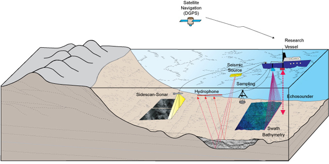
Figure 2. Illustration of the geophysical systems used to define the geologic framework. Sidescan-sonar, swath-bathymetric and seismic-reflection systems were used to define the surficial sediment distribution, depth, and underlying geology. Sampling systems were used to collect direct samples of the river-bed sediment. Differential Global Positioning System (DGPS) was used to navigate the instrumentation.

Download the full size image in PDF format (12.5 MB).


To view files in PDF format, download a free copy of Adobe Reader.


Skip USGS links group

Accessibility FOIA Privacy Policies and Notices

Take Pride in America logo USAGov logo U.S. Department of the Interior | U.S. Geological Survey
End of USGS links group