U.S. Geological Survey Open-File Report 2010-1035
Geophysical Data Collected from the St. Clair River between Michigan and Ontario, Canada (2008-016-FA)
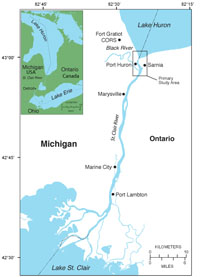
In 2007, the International Joint Commission, a body formed by the United States and Canada to manage and protect the lakes and river systems along the US and Canadian border, initiated a 5-year International Upper Great Lakes Study (IUGLS) to investigate the causes and effects of changing lake levels within the Great Lakes basin (Yuzyk and Stahkiv, 2009; http://www.iugls.org/). The Great Lakes region supports large populations, numerous industries, and diverse ecosystems. Changes in lake levels within the Great Lakes region can have major economic and environmental effects. To address these concerns, the IUGLS developed a two-phase approach: 1) to examine the physical processes and changes in the St. Clair River, and its effect on water levels within Lake Michigan-Huron, and 2) review the regulation of Lake Superior outflows and assess the need for improvements to manage evolving uses (Yuzyk and Stahkiv, 2009). To address IUGLS Phase 1 objectives, the USGS in cooperation with the U.S. Army Corps of Engineers (USACOE) conducted a geophysical and sediment sampling survey of the Upper St. Clair River to examine the geologic framework and its relation to river-bed morphology. The St. Clair River is a natural conduit between Lake Michigan-Huron and Lake Erie, and plays a key role in determining water levels within the upper Great Lakes (Yuzyk and Stahkiv, 2009; http://www.iugls.org/). The St. Clair River is approximately 44 km in length and flows south from Lake Huron to Lake St. Clair (fig. 1). The USGS survey extended from the lower reaches of Lake Huron to the mouth of the Black River (fig. 1). Two sites to the south at Marysville, MI and Port Lambton, Ontario were also surveyed to provide a comparison to the geologic framework within the Upper St. Clair study area. This report details the data–processing procedures and presents the geophysical and sample data collected by the USGS from May 29 to June 4, 2008, during USGS field activity 2008-016-FA. Geophysical data were collected with swath bathymetry, sidescan-sonar, Chirp and Boomer sub-bottom profilers. Video, digital photographs, and sediment samples of the riverbed were collected with the USGS Mini SEABed Observation and Sampling System (SEABOSS)(Blackwood and Parolski, 2001). A complete presentation and discussion of the geologic framework of the Upper St. Clair river is available in U.S. Geological Survey Open-File Report 2009–1137. |