Skip past header information
USGS - science for a changing world

U.S. Geological Survey Open-File Report 2010-1091

High-Resolution Geophysical Data Collected Within Red Brook Harbor, Buzzards Bay, Massachusetts, in 2009


Skip past contents information/ Title Page / Acknowledgments / List of Figures / Conversion Factors / Abstract / Introduction / Data Acquisition and Processing / Data Description / References Cited / Appendix 1 /


Figure 11:  Map showing the location of bottom photographs and sediment samples overlying a backscatter mosaic of Red Brook Harbor. Areas of transition between high and low backscatter, and large areas of homogeneous backscatter, were chosen for 24 of the sample sites. The remaining 24 sample sites were selected with a GIS randomization routine, and will be used in future habitat modeling efforts. Red dots depict locations of bottom photographs, yellow dots mark samples located according to backscatter characteristics, and green dots show the locations of sediment sample stations that were chosen randomly. Thick shell cover on the sea floor prohibited collecting sediment samples at seven planned sample stations in the outer harbor.


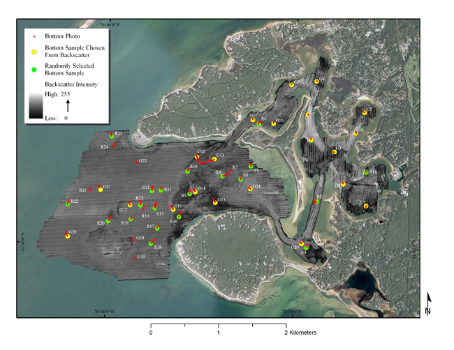
Figure 11. Map showing the location of bottom photographs and sediment samples overlying a backscatter mosaic of Red Brook Harbor, Massachussets.  Areas of transition between high and low backscatter and large areas of homogeneous backscatter, were chosen for 24 of the sample sites.  The remaining 24 sample sites were selected with a geographic information system randomization routine, and will be used in future habitat modeling efforts.  Red dots depict locations of bottom photographs, yellow dots mark sample sites chosen based on backscatter characteristics, and green dots show the locations of sediment sample stations that were chosen randomly.  Seven sites marked by photographs only are locations where dense shell cover on the sea floor prohibited the collection of sediment samples. (Aerial photography of land areas from Environmental Systems Research Institute (2010) World Imagery ArcGIS Map Service, aerial photography of water areas from [Massachussets] Office of Geographic Information (2010).)


Download the full size image in PDF format.


To view files in PDF format, download a free copy of Adobe Reader.


Skip USGS links group

Accessibility FOIA Privacy Policies and Notices

Take Pride in America logo USAGov logo U.S. Department of the Interior | U.S. Geological Survey
End of USGS links group