U.S. Geological Survey Open-File Report 2010-1091
High-Resolution Geophysical Data Collected Within Red Brook Harbor, Buzzards Bay, Massachusetts, in 2009
|
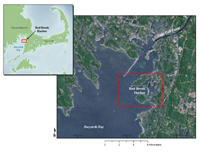
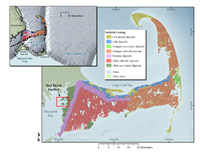
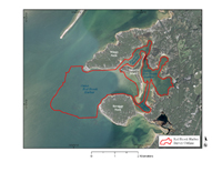
This report presents the results of a high-resolution geophysical survey within Red Brook Harbor, Massachussets, conducted by the U.S. Geological Survey (USGS). Red Brook Harbor is located on the eastern edge of Buzzards Bay, south of the Cape Cod Canal (fig. 1). The survey area was approximately 7 square kilometers (km2), with depths ranging from 0 to approximately 10 meters (m). Surveying was conducted aboard the USGS Research Vessel (R/V) Rafael (fig. 2), from September 28 through November 17, 2009. The purpose of the Red Brook Harbor survey was twofold. These data will be integrated in an ongoing, cooperative project between the USGS and the Massachusetts Office of Coastal Zone Management (CZM) designed to map the geologic framework of the inner continental shelf offshore Massachusetts. Data will be used to help inform management decisions relating to coastal and marine resources, assess environmental changes caused by natural and anthropogenic impacts, and provide a geologic framework for additional scientific studies. In addition to inclusion within the USGS-CZM project, these Red Brook Harbor data will be used to assess the shallow-water capabilities of the geophysical systems deployed for the survey and establish resolution benchmarks for the interferometric sonar system. The marine and terrestrial morphology of Cape Cod Peninsula and its neighboring islands to the south were shaped by glacial processes resulting from the advance and retreat of the Laurentide ice sheet during the late Pleistocene Epoch. Sea-level rise following the recession of the ice sheet from present day Cape Cod, approximately 18,000 years before present, has further shaped regional landforms (Oldale, 1992). Red Brook Harbor is a shallow bay with a sandy shoreline on the eastern edge of Buzzards Bay. The harbor is surrounded on three sides by low-lying sand and gravel ice-contact sediments deposited along the eastern flank of the Buzzards Bay lobe of the Laurentide ice sheet (Oldale, 1992; Gutierrez and others, 2003) (fig. 3). Bassets Island separates the harbor into an inner and an outer harbor. Water depths reach approximately 10 m in the outer harbor, while the inner harbor is approximately 2 m deep. The shallow, well protected inner harbor has a channel dredged to 3 m and is a popular moorage for shallow-draft vessels. Figure 4 shows an overview of Red Brook Harbor. |
|