Skip past header information
USGS - science for a changing world

U.S. Geological Survey Open-File Report 2010-1178

Geophysical Data from offshore of the Gulf Islands National Seashore, Cat Island to Western Horn Island, Mississippi


Skip past navigation menu to main textTitle Page / Contents / List of Figures / Conversion Factors and Datum / Abstract / Introduction / Data Acquisition and Processing / Data Catalog / Acknowledgments / References Cited


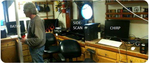
Figure 4 . Data acquisition setup onboard the R/V Tommy Munro. From left to right, interferometric bathymetry (SwathPlus 234/468), sidescan-sonar (Klein 3000/3900), and 512i sub-bottom Chirp seismic-reflection acquisition computers.

Figure 4 is a photograph of data acquisition setup onboard the R/V Tommy Munro. From left to right, submetrix bathymetry, sidescan-sonar, and 512i sub-bottom seismic reflection acquisition computers.

Skip USGS links group

Accessibility FOIA Privacy Policies and Notices

Take Pride in America logo USAGov logo U.S. Department of the Interior | U.S. Geological Survey
End of USGS links group