- Data Access
- Raster, Vector, and Text Data Description
- Data Preview
1. Data Access
The spatial data in this report are delivered in two different formats:
Selected raster and vector data can be viewed within an ArcMap™ 9.2 map document (2010-1178.mxd). Refer to the “Raster, Vector, and Text Data Description” section below for details on file descriptions and locations.
Projection:
Raster data: Universal Transverse Mercator (UTM) Meters, Zone 16N, WGS84 Datum (unless accompanied by '_dd' in the file name, in which case they are GeoTIFF images in Geographic Coordinate System, WGS84 Datum.)
Vector data: Geographic Coordinate System, WGS84 Datum.
Viewing the data:
The data can be accessed in several ways, depending on software availability:
Viewing the map documents:
ArcGIS® 9.2 or higher:
Copy the GIS_Catalog folder or the GIS_Catalog zip file (619 MB; for Web downloads) to a local computer and open the ArcMap™ 9.2 map document 2010-1178.mxd. The map document is saved with relative links. As long as the file structure remains the same under the parent directory (GIS_Catalog) there is no need to change drive letters or pathways. Approximately 1.5 GB of free space is needed to save the data and extract it to a local drive.
Data download:
Raster and vector data are stored and compressed within zip files in order to facilitate Web downloads. WinZip® files of the individual data layers are linked within the Data Preview section. See below for specific download instructions.
Raster data are stored in ESRI® Binary grid, PNG, or GeoTIFF image format. Vector data are stored as shapefiles.
If WinZip® is not currently installed on the local system, go to WinZip® <http://www.winzip.com> to download the latest version of the WinZip® utility.
2. Raster, Vector, and Text Data Description
This section describes the location of the raster and vector data within the folder storage structure of the DVD or Web page. Raster data are delivered as image files, or ESRI® Binary Grids. Vector data are delivered as ESRI® Shapefiles.
Grid: ESRI® binary grid.
Image: binary image (GeoTIFF, PNG).
Shape file: ESRI® file format for point, polyline, or polygon vector data.
 GIS_Catalog GIS_Catalog
This folder contains:
Bathy
- tmunro_50m – Grid: Bathymetry at 50-m resolution
- tmunro_50m_hs.tif – Image: Hillshade relief image at 50-m resolution; UTM Zone 16 (TIFF)
- tmunro_1m_bathycontours_MLLW.shp – Shapefile: Bathymetric contours at 1-m interval
- tmunro_50m_dd.tif– Image: Color shaded-relief image at 50-m resolution; geographic (TIFF)
Sidescan
- 2010-012-FA_MOSAIC_CI.tif – Image: Sidescan-sonar mosaic at 1-m resolution from 2010-012-FA leg (TIFF)
- 2010-012-FA_MOSAIC_GC.tif – Image: Sidescan-sonar mosaic at 1-m resolution from 2010-012-FA leg (TIFF)
- 2010-012-FA_MOSAIC_GE.tif – Image: Sidescan-sonar mosaic at 1-m resolution from 2010-012-FA leg (TIFF)
- 2010-012-FA_MOSAIC_GW.tif – Image: Sidescan-sonar mosaic at 1-m resolution from 2010-012-FA leg (TIFF)
- 10CCT02_MOSAIC_GC.tif – Image: Sidescan-sonar mosaic at 1-m resolution from 10CCT02 leg (TIFF)
- 10CCT02_MOSAIC_GW.tif – Image: Sidescan-sonar mosaic at 1-m resolution from 10CCT02 leg (TIFF)
- 10CCT02_MOSAIC_GC.tif – Image: Sidescan-sonar mosaic at 1-m resolution from 10CCT02 leg (TIFF)
- 10CCT02_MOSAIC_GN.tif – Image: Sidescan-sonar mosaic at 1-m resolution from 10CCT02 leg (TIFF)
Seisimage
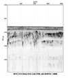
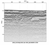
- 2010-012-FA – folder: seismic images from 2010-012FA leg (PNGs)
- 10cct02 – folder: seismic images from 10CCT02 leg (PNGs)
These folders contain PNG images of seismic-reflection profiles. These images are "hotlinked" to the geophysical tracklines within the ArcMap™ 9.2 map document 2010-1178.mxd. The folders within the “Seisimage” directory are named according to field activity survey ID's from the Woods Hole and the St. Petersburg USGS offices.
Using "hotlink" within ArcGIS 9.2 or higher:
In order to "hotlink" to the seismic images, the seismic tracklines must be selected within the Table of Contents. The hotlink feature (lightning bolt  ) within the tools menu can then be used to display the seismic images associated with an individual trackline. ) within the tools menu can then be used to display the seismic images associated with an individual trackline.
- Open 2010-1178.mxd
- Select a seismic trackline in the Table of Contents.
- Select the lightning bolt tool and click on an individual trackline to view an image of the seismic data.
Tracklines
** Within 2010-1178.mxd: Seismic-reflection tracklines are hotlinked to PNGs stored within the“Seisimage” directory. **
- 2010-012-FA_subx_Tracklines.shp – Shape file: Swath bathymetric trackline for 2010-012-FA leg
- 10CCT02_subx_Tracklines.shp – Shape file: Swath bathymetric trackline for 10CCT02 leg
- 2010-012-FA_SeismicShot_500.shp – Shape file: Shot points at 500-shot interval for seismic data for 2010-012-FA leg
- 10CCT02_SeismicShot_500.shp – Shape file: Shot points at 500-shot interval for seismic data for 10CCT02 leg
- 2010-012-FA_SeismicTrackline.shp – Shape file: Seismic tracklines for 2010-012-FA leg
- 10CCT02_SeismicTrackline.shp – Shape file: Seismic tracklines for 10CCT02 leg
- 2010-012-FA_k3k_Tracklines.shp – Shape file: Sidescan-sonar tracklines 2010-012-FA leg
- 10CCT02_k3900_Tracklines.shp – Shape file: Sidescan-sonar tracklines for 10CCT02 cruise
HYPACK
- 2010-012-FA – folder: raw HYPACK navigation (ASCII text) from 2010-012-FA leg
- 10CCT02 – folder: raw HYPACK navigation (ASCII text) from 10CCT02 leg
Basemaps
nos80k_NGoM.shp – Medium-resolution digital vector shoreline shapefile for the Northern Gulf of Mexico. This shapefile was modified from the shapefile that was published in 1994 by NOAA/NOS/ORCA/SEA <http://www.ngdc.noaa.gov/mgg/shorelines/noaamrdvs.html>.
Map document:
2010-1178.mxd – ArcMap™ 9.2 map document containing selected data layers described above.
3. Data Preview
Downloading data:
To download raster and vector data, right click on the link within the 'Download zip file' column in the table below. 'Save Target As...' to save a compressed WinZip® file to the local hard drive. If WinZip® is not currently installed on the local system, go to WinZip® to download the latest version of the WinZip® utility.
|