Skip past header information
USGS - science for a changing world

U.S. Geological Survey Open-File Report 2010-1178

Geophysical Data from offshore of the Gulf Islands National Seashore, Cat Island to Western Horn Island, Mississippi


List of Figures

Skip past contents information

Figures

Thumbnail image of figure 1, location map of survey area in the Northern Gulf of Mexico, and link to larger figure.

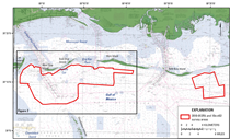
Figure 1. Location map of the Mississippi Gulf Islands survey areas for cruise IDs 2010-012-FA and 10CCT02. The red polygons outline two survey areas. The black box indicates the survey area that is the focus of this report. Figure 2 contains a more detailed view of this survey area.

Thumbnail image of figure 2, map of geophysical survey tracklines, and link to larger figure. 
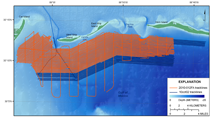
Figure 2. The R/V Tommy Munro western survey area stretching from Cat Island to western Horn Island. The lines indicate geophysical survey tracklines.
Thumbnail image of figure 3, photograph of R/V Tommy Munro underway, and link to larger figure. 
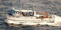
Figure 3. The R/V Tommy Munro. Photo by the Gulf Coast Research Laboratory, University of Southern Mississippi.
Thumbnail image of figure 4, photograph of dry lab of R/V Tommy Munro displaying the computer acquisition setup, and link to larger figure.

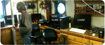
Figure 4 . Data acquisition setup onboard the R/V Tommy Munro. From left to right, interferometric bathymetry (SwathPlus 234/468), sidescan-sonar (Klein 3000/3900), and 512i sub-bottom Chirp seismic-reflection acquisition computers.


Skip USGS links group

Accessibility FOIA Privacy Policies and Notices

Take Pride in America logo USAGov logo U.S. Department of the Interior | U.S. Geological Survey
End of USGS links group