U.S. Geological Survey Open-File Report 2011-1015
Quaternary Geophysical Framework of the Northeastern North Carolina Coastal System
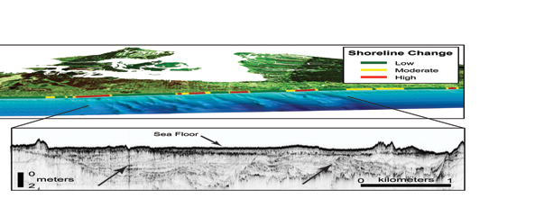 |
Figure 13. Perspective view from offshore, looking onshore near Kitty Hawk, North Carolina. The nearshore surveys in the coastal ocean off Kitty Hawk reveal a pattern of shore-oblique bars in the nearshore, shown as the “corrugated” pattern in the blue-toned bathymetric map. The bars likely influence nearshore wave characteristics and the resulting sediment transport and erosion on the beach. Alongshore variability in shoreline change is shown from SWASH surveys (see text for discussion). The shore-oblique bars appear to have an origin related to the presence of a variable shallow geologic framework, shown here in the seismic line as a large complex of cut and fill structures (arrows) related to the late Pleistocene course of the paleo-Roanoke River Valley Complex (PRVC; see text for discussion) that passes underneath Kitty Hawk.
|

![]() U.S. Department of the Interior |
U.S. Geological Survey
U.S. Department of the Interior |
U.S. Geological Survey
URL: http://pubsdata.usgs.gov/pubs/of/2011/1015/figure13.html
Page Contact Information: GS Pubs Web Contact
Page Last Modified: Thursday, 08-Dec-2016 00:29:37 EST
