U.S. Geological Survey Open-File Report 2011-1015
|
By E.R. Thieler, D.S. Foster, D.J. Mallinson, E.A. Himmelstoss, J.E. McNinch, J.H. List, and E.S. Hammar-Klose
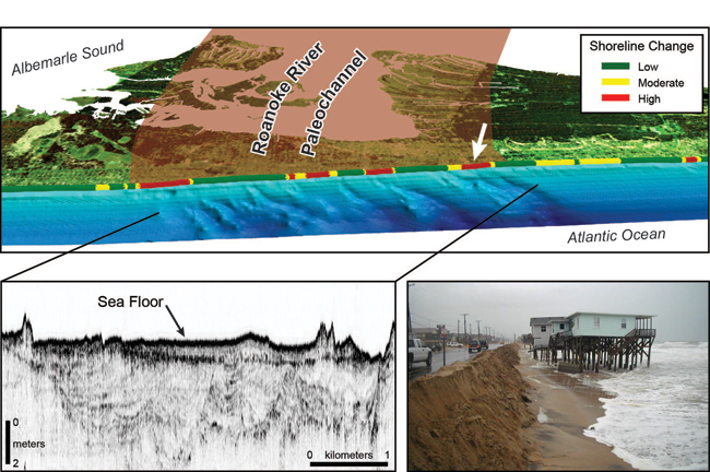
The geology of the North Carolina coastal system influences rates and magnitudes of coastal change. The upper image is a perspective view of the inner continental shelf and nearshore bathymetry and the adjacent barrier island, looking onshore near Kitty Hawk, North Carolina. A pattern of shore-oblique bars is visible as the “corrugated” pattern in the blue-toned bathymetric map. The shore-oblique bars appear to have an origin related to the presence of a variable shallow geologic framework, shown here in the seismic line (lower left image) as a large complex of cut and fill structures related to the Late Pleistocene course of the Roanoke River that passes underneath Kitty Hawk. These bars likely influence nearshore wave characteristics and the resulting sediment transport and erosion on the beach, which is shown in the alongshore-varying pattern of low, moderate and high shoreline change in the upper image. The white arrow in the upper image indicates the location of the photo at lower right. This location experiences relatively high magnitudes of shoreline change, particularly during storms when waves are large. U.S. Department of the Interior U.S. Geological Survey U.S. Geological Survey, Reston, Virginia: 2013
For product and ordering information:
For more information on the USGS—the Federal source for science about the Earth, its natural and living resources, natural hazards, and the environment:
Suggested citation:
Any use of trade, product, or firm names is for descriptive purposes only and does not imply endorsement by the U.S. Government.
Although this report is in the public domain, permission must be secured from the individual copyright owners to reproduce any copyrighted material contained within this report. To view files in PDF format, download a free copy of Adobe Reader. |

![]() U.S. Department of the Interior |
U.S. Geological Survey
U.S. Department of the Interior |
U.S. Geological Survey
URL: http://pubsdata.usgs.gov/pubs/of/2011/1015/title_page.html
Page Contact Information: GS Pubs Web Contact
Page Last Modified: Thursday, 08-Dec-2016 00:29:51 EST