U.S. Geological Survey Open-File Report 2011-1015
Quaternary Geophysical Framework of the Northeastern North Carolina Coastal System
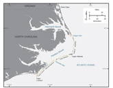
The purpose of this report is to publish the data collected as part of this regional mapping project. The report contains spatial datasets of high-resolution geophysical (bathymetry, backscatter intensity, seismic reflection, and ground-penetrating radar) and sedimentary (core and grab-sample) data. The high-resolution geophysical data were collected during numerous surveys within the back-barrier estuarine system, along the barrier island complex, in the nearshore, and along the inner continental shelf (fig. 1). Sediment cores were taken on the mainland and along the barrier islands, and both cores and grab samples were taken on the inner shelf. Data collection was a collaborative effort between the U.S. Geological Survey (USGS) and several other institutions including East Carolina University (ECU), the North Carolina Geological Survey, the Virginia Institute of Marine Science (VIMS), and the University of Pennsylvania. |

![]() U.S. Department of the Interior |
U.S. Geological Survey
U.S. Department of the Interior |
U.S. Geological Survey
URL: http://pubsdata.usgs.gov/pubs/of/2011/1015/introduction.html
Page Contact Information: GS Pubs Web Contact
Page Last Modified: Thursday, 08-Dec-2016 00:29:47 EST