U.S. Geological Survey Open-File Report 2011-1015
Quaternary Geophysical Framework of the Northeastern North Carolina Coastal System
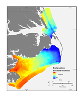
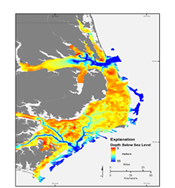
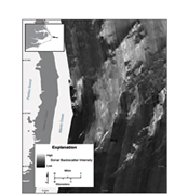
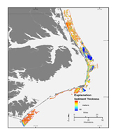
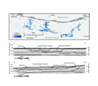
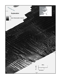
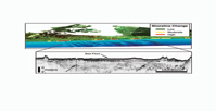
The northeastern North Carolina coastal system contains an exceptionally thick and well preserved Quaternary stratigraphic record. The major goal of this project was to map this Quaternary section on the inner continental shelf, the Outer Banks barrier islands, the Albemarle-Pamlico estuarine system, and adjacent mainland areas. This information is used to define the geologic framework, develop a detailed evolutionary history, and understand the ongoing processes driving the evolution of this large, complex, and rapidly changing coastal system. The regional synthesis described here includes a basic understanding of the geologic characteristics and process dynamics of the modern barrier island-estuarine system. Regional SettingThe Albemarle Embayment is a structural basin bounded by the Norfolk Arch to the north and the Miocene Cape Lookout High to the south (Brown and others, 1972). During the latest Quaternary, the embayment has been bounded to the east by a relict inter-stream divide, which is now occupied by the Outer Banks barrier islands (Mallinson and others, 2005). Pliocene and Quaternary sequences dip and thicken toward the center of the basin, beneath northern Pamlico Sound (fig. 7). At the southern end of Pamlico Sound, the sequences thin onto an older antecedent high. Eighteen seismic sequences can be defined within the Quaternary section (Mallinson and others, 2005; 2010a). Sequence boundaries and flooding surfaces were mapped to provide a three-dimensional perspective on the evolution of the basin fill. Correlation of seismic sequences is complicated by numerous complex fluvial valley incisions that occur in association with sequence boundaries. The incised valleys (fig. 8) correspond to the Roanoke, Pamlico, Tar, and Neuse paleodrainage systems. The paleo-Roanoke River Valley Complex (PRVC) is a late Pleistocene to Holocene valley incised to approximately 35 m below present sea level in Albemarle Sound and is approximately 9 km wide. The PRVC meanders to the east, passing beneath the northern Outer Banks at Kitty Hawk (Boss and others, 2002; Mallinson and others, 2005; Browder and McNinch, 2006). Seismic data from Pamlico Sound show multiple large (30+ m deep, several km wide) incised valleys, and numerous smaller incised channels within the Quaternary section. The paleo-Pamlico contains two major stream systems that drain to the southwest and is bounded to the east by the Outer Banks relict inter-stream divide. The paleo-Tar and Neuse River systems drain to the southeast. These valleys merge with the Pamlico paleodrainage in a major confluence beneath Ocracoke Inlet and northern Core Banks (Mallinson and others, 2010a). Inner Continental Shelf Morphology and Sediment CoverThe inner continental shelf was mapped using sidescan sonar, interferometric swath bathymetry, and high-resolution chirp and boomer subbottom profiling systems. Water depths range from 7 m (mid-shoreface) to 34 m (inner shelf). Late Pleistocene stratigraphic units comprise the shallow geologic framework of this region (Thieler and others, in review). Regional to local-scale variations in the geometry and lithology of these units dictate the character of sediments on the sea floor as shown by sidescan sonar imagery (fig. 9) in this and other studies (Swift and others, 1978). For example, areas of high acoustic backscatter typically correspond to coarse-grained fluvial and marine sediments representing several Pleistocene units that crop out on the sea floor. The distribution of Recent sediment (above the Holocene ravinement surface) on the shoreface and inner shelf (fig. 10) suggests that sediment availability to the coast is controlled by the underlying geologic framework, which influences the geomorphology of the overall barrier island system. For example, sediment-rich coastal segments have wide, accretionary barriers dominated by beach ridges; sediment-starved coastal segments have narrow, washover-dominated barriers (Riggs and others, 2009). Although the large cape-associated shoals in the study area, Diamond Shoals at Cape Hatteras and Lookout Shoals at Cape Lookout, were not mapped in this study, smaller shoals were included. False Cape, Platt, Wimble, and Kinnakeet Shoals are composed of both underlying indurated sediments and unconsolidated sediment (Mallinson and others, 2010a; Thieler and others, in review). Historical bathymetric comparisons of large sand waves on the shoals suggest sand wave migration rates of ~100 m per decade (Thieler and others, in review). Sediment transport patterns inferred from the analysis of modern bedforms suggest that the inherited paleotopography of the present sea floor may exert a primary influence on near-bottom currents and thus sediment transport pathways (Swift and Freeland, 1978; Swift and others, 1978; Thieler and others, in review). The inner shelf off Hatteras Island is composed of a variety of Quaternary sediments that have been variably preserved through multiple regressions and transgressions. A network of tidal creek lithosomes up to 12 m thick (fig. 11) is preserved in the shallow subsurface between Oregon Inlet and Cape Hatteras. The Tar-Neuse-Pamlico paleodrainage seaward of Ocracoke Inlet exhibits similar characteristics (Mallinson and others, 2010a; Thieler and others, in review). The inner continental shelf between Cape Hatteras and Cape Lookout is characterized by a variety of shore-perpendicular to shore-oblique morphologic features termed “sorted bedforms” (fig. 12) in reference to the sorting of sediment grain size that has been observed in such bedforms at many inner shelf locations (Murray and Thieler, 2004; Goff and others, 2005; Trembanis and Hume, 2011). The bedforms have typical wavelengths of 100-300 m and heights up to 1 m and extend seaward across the entire study area. Nearshore Geologic FrameworkSurveys of the nearshore sea-floor surface and shallow subbottom utilizing an interferometric swath bathymetry sonar system and a chirp subbottom profiler (fig. 13) suggest a relation between partial exposure of pre-modern, nonsandy substrates in the surf zone and bar morphodynamics, leading to the repeated occurrence of shoreline hotspots (McNinch, 2004; Browder and McNinch, 2006; Miselis and McNinch, 2006; Schupp and others, 2006). Results show:
Coastal areas with limited sand supplies such as North Carolina are significantly influenced by the geologic framework of older stratigraphic units that occur beneath and seaward of the shoreline. In this area, as with much of the Eastern United States, rivers no longer introduce significant quantities of sand to the coastal system. The sediment available to maintain modern beaches, therefore, is derived either from erosion of the shoreline or from erosion of the inner continental shelf. Thus, antecedent geology of the marine and subaerial portions of the coastal zone can determine the morphology of the nearshore zone and can strongly influence modern coastal change. Barrier Island Shallow StratigraphyGround-penetrating radar surveys along the Outer Banks barrier islands show multiple radar facies including migrating inlet, nonmigrating inlet, and flood-tidal delta or overwash (Smith and others, 2009; Mallinson and others, 2010b). Previously undocumented paleo-inlet channels constitute a significant portion of the shallow geologic framework between Oregon Inlet and Cape Hatteras (Mallinson and others, 2010b). Migrating inlet facies occur under the widest portions of the islands, whereas narrow portions of the island are underlain by nonmigrating inlet facies or flood-tide delta/overwash facies. This geologic/geomorphic relation is attributed to the successional stage of island evolution during transgression and to sediment transport processes associated with the different inlet types (Mallinson and others, 2010b). Shoreline ChangesA series of high-resolution shoreline change measurements with the USGS SWASH system has opened a new window on coastal change processes in North Carolina. At time scales from days to years, data demonstrate that shoreline change in North Carolina consists of hotspots of erosion alternating with areas of little change or accretion (List and others, 2006). Hotspots of erosion often result in focused areas of damage to structures, dunes, and roadways and are thus of concern for coastal management. Patterns of coastal change at the shoreline appear to be linked to geologic features in the nearshore and inner continental shelf as described above (for example, bathymetry, sand distribution). These data, combined with surveys of framework geology, are now providing high-quality field cases for testing and improving numerical models for predicting coastal change. The shoreline position time series is also serving as the basis for new research, demonstrating that improved observations are a critical first step toward better understanding and modeling of large-scale coastal processes.
|

![]() U.S. Department of the Interior |
U.S. Geological Survey
U.S. Department of the Interior |
U.S. Geological Survey
URL: http://pubsdata.usgs.gov/pubs/of/2011/1015/discussion.html
Page Contact Information: GS Pubs Web Contact
Page Last Modified: Thursday, 08-Dec-2016 00:29:33 EST