U.S. Geological Survey Open-File Report 2011–1149
Sea-Floor Geology of Long Island Sound North of Duck Pond Point, New York
![]() Title |
List of Figures |
Conversion Factors |
Abstract |
Introduction |
Setting |
Methods |
Bathymetry |
Sediments |
Bottom Photography |
GIS Data Catalog |
Summary |
Acknowledgments |
References |
Contacts
Title |
List of Figures |
Conversion Factors |
Abstract |
Introduction |
Setting |
Methods |
Bathymetry |
Sediments |
Bottom Photography |
GIS Data Catalog |
Summary |
Acknowledgments |
References |
Contacts
 |
||
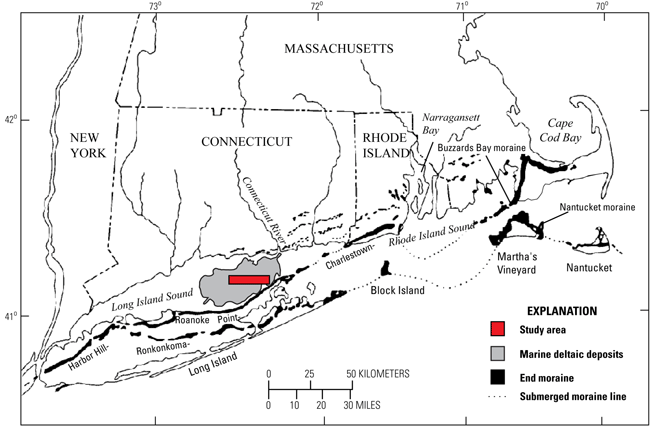
Figure 2. Map showing the location of end moraines, submerged moraine lines in southern New York and New England (modified from Gustavson and Boothroyd, 1987), and the extent of marine deltaic deposits from the Connecticut River (Lewis and DiGiacomo-Cohen, 2000). The Ronkonkoma-Block Island-Nantucket end moraine represents the maximum advance of the Laurentide Ice Sheet about 20,000 years ago, and the Harbor Hill-Roanoke Point-Charleston-Buzzards Bay end moraine represents a retreated ice-sheet position from about 18,000 years ago (Uchupi and others, 2001). |
||


