U.S. Geological Survey Open-File Report 2011–1149
Sea-Floor Geology of Long Island Sound North of Duck Pond Point, New York
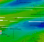
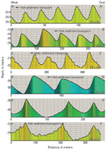
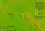
The study area has several northeast-southwest trending bathymetric lows, surrounded by bathymetric highs (fig. 14). Water depths in the study area range from about 9 to 53 m. The southeast corner of the study area is the most rugged, containing both the shallowest and deepest areas on a bank of sand waves and in a nearby scour depression, respectively. The majority of the sea floor is covered with complex configurations of sand waves, megaripples, and ripples (fig. 15). Transverse and barchanoid waves are found throughout the study area and commonly one sea-floor morphology will overlap with and grade into another. Boulders are present in the southeast. Two shipwrecks are also visible in the bathymetry imagery; one is 31 m deep and the other is 25 m deep (National Oceanic and Atmospheric Administration, 2008). Three parallel, northeast-southwest trending depressions are located in the eastern half of the study area. Within these elongate (several kilometers in length) depressions are smaller depressions (tens of meters in length) formed, presumably by turbulence, in the lee of sand waves. The southeastern side of the middle elongate depression tends to have sand waves, while the northwestern side tends to have a smooth to rippled sea floor (figs. 16 and 17). The northern depression also has large areas of smooth to rippled sea floor, mostly in the deeper parts. In the elongate depressions, the contact between the sand waves and the smooth to rippled sea floor is typically abrupt. Barchanoid megaripples and sand waves are more common in the elongate depressions where sediment supply is limited and they tend to have sinusoidal crests that are well aligned, normal to their crest orientation, forming distinct lines of waves over 4 km in length that are parallel to the axes of the depressions (figs. 17 and 18). The lines are made up of northwest-southeast oriented crests with concavity towards the southwest. The northeastern ends of these lines are megaripples, which progressively grow in size and turn into complex barchanoid sand waves towards the southwest (fig. 18). The barchanoid waves have wavelengths of 30 to 50 m and heights of 2 to 5 m. Their horns generally connect to those of nearby barchanoid waves and also bifurcate into megaripples. Transverse waves and megaripples have crests that are arced, bifurcated, and sinusoidal. This bedform morphology is more common on the crests and flanks of shoals where sand supply is abundant. Arc-crested megaripples occur in the northwest corner of the study area. They are concavely oriented to the southwest, curving around a shoal (fig. 19). They have wavelengths of 20 to 30 m and likely owe their morphology and orientation to currents refracting around the adjacent bathymetric high. To the east, the crests of larger sand waves tend to bifurcate and some are sinusoidal. The bifurcated sand waves have wavelengths of 100 to 200 m and are covered in megaripples with crests oriented oblique to the sand waves. The megaripples have wavelengths of 10 to 30 m. The sinusoidal waves lack megaripples and have wavelengths of 40 to 120 m. The majority of transverse and barchanoid sand waves indicate a westward to southwestward direction of sediment transport in most of the study area based on sand-wave profiles (fig. 20) and the orientation of barchanoid horns. However, some sand waves in the southeast have either symmetrical profiles or profiles that indicate a northeastward sediment transport direction. Straight-crested waves, which grade into barchanoid waves, are located in the southeast part of the study area and have wavelengths of 60 to 130 m (fig. 21). They are located along the southern flank of a dip in the bathymetric high that separates two elongate depressions. The waves are 5 to 10 m high, symmetrical in profile (fig. 20) and have moats at either end of the crest. Smaller sand waves and megaripples (with heights of about 1 m) have formed on some of the flanks of the sand waves. The straight-crested sand waves in the study area are much like those found on Georges Bank, offshore of Cape Cod, Mass., (Todd and Valentine, 2012; Valentine and others, 2002) and in eastern Long Island Sound (Poppe and others, 2011a). On Georges Bank, the moats around straight-crested sand waves are thought to have formed from the scour of sand from gravelly areas, as the moats and area between the waves are gravelly. Boulders are present in several areas across the southeast part of the study area where they occur in scour depressions, sand-wave troughs, and other sediment-starved areas. They are visible in the bathymetric imagery as small mounds, many of which are several meters across (fig. 22). Although these boulders are three to five kilometers offshore, they are likely an exposed flank of the Harbor Hill-Roanoke Point-Orient Point moraine segment deposited about 18,000 years ago. |