U.S. Geological Survey Open-File Report 2011–1149
Sea-Floor Geology of Long Island Sound North of Duck Pond Point, New York
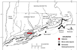
Long Island Sound, a major east-coast estuary, is floored by glacial, transitional, and marine sediments. About 20,000 to 24,000 years ago, the Laurentide Ice Sheet was at its maximum extent and covered the sound and parts of Long Island, which is marked by the Ronkonkoma-Block Island-Nantucket moraine system (fig. 2; Sirkin, 1980; Stone and Borns, 1986; Uchupi and others, 2001). The ice sheet's southern extent retreated northward about 18,000 years ago to a position marked by the Harbor Hill-Roanoke Point-Orient Point-Charlestown-Buzzards Bay moraine line (Uchupi and others, 2001). As the ice continued to melt and the Laurentide Ice Sheet retreated northward, glacial lakes formed between the ice front and the northern moraines, covering much of present-day Long Island, Block Island, and Rhode Island Sounds and Narragansett Bay (Uchupi and others, 2001; Needell and others, 1983). From 17,500 to 15,500 years ago, Glacial Lake Connecticut covered much of modern Long Island Sound, depositing lake sediments generally 80 meters (m) thick and locally up to 150 m (fig. 3; Lewis and DiGiacomo-Cohen, 2000; Uchupi and others, 2001). Glacial Lake Connecticut started to drain as its spillway eroded. After the lake drained, this land was eroded during subaerial exposure and marine transgression (Lewis and DiGiacomo-Cohen, 2000). Between 13,000 and 9,500 years ago, Glacial Lake Hitchcock, located along the present-day Connecticut River in central Massachusetts and southern Vermont, drained, and its sediments were transported down the Connecticut River and deposited in a marine delta that prograded across much of eastern Long Island Sound (Lewis and DiGiacomo-Cohen, 2000; Stone and others, 1998). |