U.S. Geological Survey Open-File Report 2012–1004
Sea-Floor Geology in Central Rhode Island Sound South of Sakonnet Point, Rhode Island
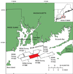
Bathymetric data, originally collected to update nautical charts, can be verified with bottom photography and sediment samples in order to interpret sea-floor geology. In 2008, the National Oceanic and Atmospheric Administration (NOAA) obtained 63 square kilometers (km²) of multibeam-echosounder data in central Rhode Island Sound, 15 km south of Sakonnet Point, Rhode Island, to complete survey H11995 (fig. 1). The U.S. Geological Survey (USGS) took bottom photographs, video, and sediment samples from 27 stations in this area during June 2011 to verify an interpretation of the bathymetric data. The purpose of this report is (1) to release multibeam bathymetric imagery and grids, surficial sediment data, and bottom photography from the sea floor in this area of central Rhode Island Sound and (2) to describe the sea-floor features, processes, and sediment textures present. These data and interpretations serve as important base maps for future studies of benthic habitats and resource management projects. |