U.S. Geological Survey Open-File Report 2012–1004
Sea-Floor Geology in Central Rhode Island Sound South of Sakonnet Point, Rhode Island
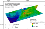
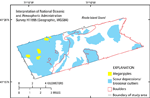
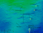
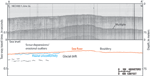
The eastern and central parts of the study area contain bathymetric highs, shoaling to 22 m, whereas a bathymetric low dominates the southwestern area, reaching depths of 40 m (fig. 12). Several geologic features are apparent in the bathymetry including scour depressions and associated erosional outliers, megaripples, and boulders (fig. 13). In general, about half of the sea floor in the study area is covered by scour depressions and erosional outliers and the other half is bouldery, although areas with these features overlap in some places. Small areas of smooth sea floor consisting of undisturbed modern marine sediments are found in the deeper parts of the western and northern parts of the study area, and on top of the erosional outliers. Scour depressions are areas of the sea floor where bottom stresses have eroded sediments. In the study area they average 0.5 m in depth, have distinct steep sides and flat to hummocky floors, tens to hundreds of meters wide. In places, scour depressions surround erosional outliers, which are the areas of the sea floor where sediments have not been eroded (fig. 14). Shallow, higher energy edges of scour depressions are commonly adjacent to gravelly and bouldery deposits, whereas deeper, lower energy edges are abutted by Holocene marine deposits. The scour depressions and erosional outliers cover about 32 km² of the sea floor in the study area and occur in moderate to deep water throughout much of the western half of the study area and in several patches in the east. Scour depressions occur in a variety of shapes from elongate to tabular, while many of the larger scour depressions are crescent shaped with the tips pointing to the northeast and northwest. Smaller scour depressions tend to be elongate in a north-south orientation. Seismic-reflection profiles from within the study area show that areas with scour depressions and erosional outliers tend to be underlain by glaciolacustrine and fluvial sediments (fig. 15; McMullen and others, 2009). Scour depressions and erosional outliers have been observed in nearby areas of Rhode Island and Block Island Sounds (McMullen and others, 2007; McMullen and others, 2011; Poppe and others, 2011; Poppe and others, 2012). Scour depressions are further discussed in the Sediments section of this report. Several areas of megaripples, which are bedforms with heights of 0.2 to 1 m (Ashley, 1990), occur on the tops of erosional outliers on the northwestern bathymetric high, together covering an area of less than 1 km² (fig. 14). The megaripples in the study area typically have 20-m wavelengths, 20- to 50-cm heights, and east-west oriented crest lines. Bouldery areas, covering about 34 km² of the sea floor, are generally located on the bathymetric high in the eastern part of the study area (fig. 16). The eastern bathymetric high is a submerged segment of the Harbor Hill-Roanoke Point-Charlestown-Buzzards Bay moraine line, and contains boulders that were transported and deposited by the Laurentide Ice Sheet about 18,000 years ago. The bathymetric data show that boulders in the study area are up to 10 m in diameter.
|