 |
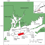
Figure 1. Location of National Oceanic and Atmospheric Administration (NOAA) Survey H11995 study area (red polygon) in relation to other NOAA surveys in Rhode Island Sound that have been interpreted as part of this series of reports including: H11320 (McMullen and others, 2007), H11321 (McMullen and others, 2008), H11322 (McMullen and others, 2009), H11922 (Poppe and others, 2011), and H11996 (McMullen and others, 2011). |
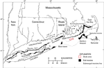 |
Figure 2. Map of end moraines (black polygons) and submerged ridges (dashed lines) in southern New York and New England (modified from Gustavson and Boothroyd, 1987) with study-area location (red polygon). The Ronkonkoma-Block Island-Nantucket end moraine represents the maximum advance of the Laurentide Ice Sheet about 20,000 to 24,000 years ago, while the Harbor Hill-Roanoke Point-Charlestown-Buzzards Bay end moraine, of which a submerged segment crosses through the study area, represents a retreated ice-sheet position from about 18,000 years ago (Uchupi and others, 2001). |
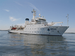 |
Figure 3. Photograph showing the starboard-side view of the National Oceanic and Atmospheric Administration Ship Thomas Jefferson, which was used to collect bathymetric data in the study area. |
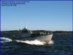 |
Figure 4. Photograph showing the National Oceanic and Atmospheric Administration Launch 3102, one of two launches used to collect bathymetric data in the study area. |
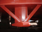 |
Figure 5. Photograph showing a RESON SeaBat 7125 multibeam echosounder, hull-mounted to National Oceanic and Atmospheric Administration Ship Thomas Jefferson, which was used to collect bathymetric data. |
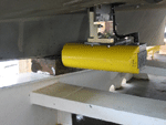 |
Figure 6. Photograph showing a RESON SeaBat 8125 multibeam echosounder, hull-mounted to National Oceanic and Atmospheric Administration Launch 3101, which was used to collect bathymetric data. |
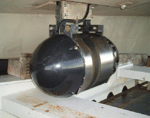 |
Figure 7. Photograph showing a RESON SeaBat 8101 multibeam echosounder, hull-mounted to National Oceanic and Atmospheric Administration Launch 3102, which was used to collect bathymetric data. |
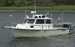 |
Figure 8. Photograph showing the U.S. Geological Survey research vessel Rafael, which was used to collect sediment samples and photographic data. |
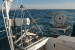 |
Figure 9. Photograph showing the small Seabed Observation and Sampling System (SEABOSS), a modified Van Veen grab sampler equipped with still and video cameras, mounted on the aft starboard side of the research vessel Rafael. The system uses a winch, mounted on a davit (left), and a take-up reel for the video-signal and power cable (right). |
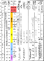 |
Figure 10. Chart showing the relations among phi sizes, millimeter diameters, size classifications (Wentworth, 1922), and American Society for Testing and Materials and Tyler sieve sizes. Chart also shows the corresponding intermediate diameters, grains per milligram, settling velocities, and threshold velocities for traction.
cm/sec, centimeter per second; m, meter; mg, milligram; mm millimeter; µm, micrometer; ", inch. |
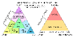 |
Figure 11. Sediment-classification scheme from Shepard (1954), as modified by Schlee (1973) and Poppe and others (2004). |
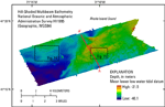 |
Figure 12. Hill-shaded multibeam bathymetric image of National Oceanic and Atmospheric Administration survey H11995 in Rhode Island Sound. Warmer colors (reds) represent shallower areas and cooler colors (blues) represent deeper areas. Locations of figures 14 and 16 and seismic-reflection profile A-A' in figure 15 are also shown.
WGS84, World Geodetic System 1984. |
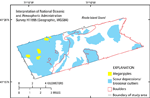 |
Figure 13. Map showing interpretation of sea-floor features in the study area, including megaripples, scour depressions and erosional outliers, and boulders. Areas of the sea floor within the study area that are not outlined are predominately undisturbed modern marine sediments. Interpretation based on multibeam bathymetry from National Oceanic and Atmospheric Administration survey H11995 and sediment samples and bottom photography from U.S. Geological Survey cruise 2011-006-FA. WGS84, World Geodetic System 1984. |
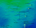 |
Figure 14. Detailed multibeam bathymetric image of erosional outliers, scour depressions, and megaripples in the northwestern part of the study area. Artifacts introduced during acquisition and processing of the bathymetric data can also be seen. Location of image shown in figure 12. |
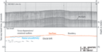 |
Figure 15. Seismic-reflection profile A-A', a section of line 2a obtained during cruise NECH80-1 on the research vessel Neecho in 1980 (McMullen and others, 2009), with interpretation. Line shows a fluvial unconformity in the south, under an area dominated by erosional outliers and scour depressions, and glacial drift elsewhere. Location of line shown in figure 12. |
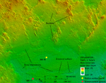 |
Figure 16. Detailed multibeam bathymetric image of boulders, scour depressions, and erosional outliers of relatively undisturbed modern marine sediments in the central part of the study area. Location of image shown in figure 12. |
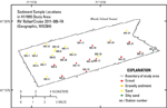 |
Figure 17. Map showing locations of sediment samples taken during U.S. Geological Survey cruise 2011-006-FA aboard research vessel (RV) Rafael. Warmer colors (reds) indicate coarser grained sediment; cooler colors (green) indicate finer grained sediment.
WGS84, World Geodetic System 1984. |
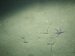 |
Figure 18. Photograph from station 995-2 showing a flat to undulating, sandy sea floor composed of relatively undisturbed modern marine sediments. Note the presence of burrows, worm tubes, and starfish. Location of photograph shown in figure 20. |
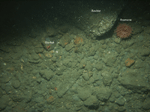 |
Figure 19. Photograph from station 995-16 showing a gravelly sea floor typical of areas where winnowed glacial drift is exposed. Note the prevalence of gravel and presence of a boulder, an anemone, and starfish. The gravel and boulder are encrusted with algae and hydrozoans. Location of photograph shown in figure 20. |
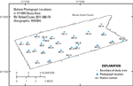 |
Figure 20. Map showing locations of bottom photographs taken during U.S. Geological Survey cruise 2011-006-FA aboard the research vessel (RV) Rafael.
WGS84, World Geodetic System 1984. |


