U.S. Geological Survey Open-File Report 2012–1004
Sea-Floor Geology in Central Rhode Island Sound South of Sakonnet Point, Rhode Island
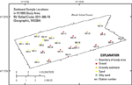
Sediment DistributionThe sea floor in the study area is variably composed of gravel, gravelly sediment, sand, and silty sand (fig. 17). The sea floor in the west is mostly sand (fig. 18), with the exception of a few small bathymetric highs composed of gravel. The eastern bathymetric high, a submerged segment of the Buzzards Bay moraine, is dominated by gravel and gravelly sediment (fig. 19). One sample, located in a bathymetric low in the southeastern corner of the study area, is silty sand. The sandy sea floor in the western part of the study area is characterized by a complex patchwork of scour depressions and intervening erosional outliers. For example, stations 995-8 and 995-10 are located on the erosional outliers, while neighboring station 995-9 is located in a scour depression. Although all three of these samples are sand, the two samples from the erosional outliers contain more mud and have a finer mean grain size (2.5 phi) than the sample from the scour depression (0.5 phi). Similarly, stations 995-17 and 995-18 are a pair of neighboring stations in a scour depression composed of gravel and on an erosional outlier composed of sand, respectively. Due to a rougher sea floor in the coarser grained scour depressions, water is more turbulent directly above the depressions, which inhibits fine-grained deposition and promotes further scour (Murray and Thieler, 2004). Thus, we think the scour depressions initially formed from, and are maintained by, bottom stress associated with storm-generated waves, enhanced by increased turbulence from currents flowing over the coarser sea floor. Sediment DataThe sediment grain-size dataset provided here contains information on the collection, description, and texture of sediments at the 27 stations in the study area. Sediments were sampled at only 11 of the stations due to either a coarse-grained sea floor or rough sea state that prevented a sample from being obtained. Stations where samples could not be obtained were visually classified based on video and still photography obtained at the station. Visually classified stations reflect the surface sediment only, as opposed to the top 2 cm of sampled stations. They also reflect the general environment along the transect, rather than the specific location where a sample was taken. These stations have no-data values (-9999) in the textural and statistical sections of the sediment dataset. The basic structure of the dataset is a flat-file format, a matrix where rows represent individual samples and columns contain sample- and station-specific information. This matrix consists of 42 fields that are defined in the Data Dictionary below. In the GIS Data Catalog section, a Zip file contains the sediment data in three formats (a shapefile, a Microsoft Excel spreadsheet, and a comma-delimited ASCII text file) along with metadata. Data DictionaryAn integral part of any database is the dictionary that explains the structure and content. It contains a list of the fields and definitions of parameters measured. Data utilization is facilitated by reference to this compilation because it defines abbreviations and lists field names. LABNO - Unique sample identifier assigned in the laboratory STATIONID - Sample name or number assigned in the field PROJECT - Name of project under which samples were taken or data generated CRUISEID - Name or number of cruise on which sample was collected or station occupied PRINCIPAL - Name of principal investigator LATITUDE - Latitude in decimal degrees (north latitudes are positive values) LONGITUDE - Longitude in decimal degrees (west longitudes are negative values) DEPTH_M - Depth of water overlying sediment at the time of sampling, measured by a hull-mounted fathometer, corrected for draft, but not corrected for tides, in meters T_DEPTH - Depth below the sediment-water interface of the top of the sample, in centimeters B_DEPTH - Depth below the sediment-water interface of the bottom of the sample, in centimeters DEVICE - Device used to collect the sample MONTH - Number of calendar month during which the sample was collected DAY - Calendar day on which the sample was collected YEAR - Calendar year during which the sample was collected WEIGHT - Dry weight of sample, in grams ZGRAVEL - Gravel content in percent dry weight of the sample (particles with nominal diameters greater than 2 millimeters; -1 phi and larger) ZSAND - Sand content in percent dry weight of the sample (particles with nominal diameters less than 2 millimeters but greater than or equal to 0.0625 millimeter; 0 through 4 phi, inclusive) ZSILT - Silt content in percent dry weight of the sample (particles with nominal diameters less than 0.0625 millimeter but greater than or equal to 0.004 millimeter; 5 through 8 phi, inclusive) ZCLAY - Clay content in percent dry weight of the sample (particles with nominal diameters less than 0.004 millimeter; 9 phi and smaller) SEDCLASS - Sediment description based on a rigorous definition (Shepard, 1954; Schlee, 1973; Poppe and others, 2004)
MEDIAN - Middle point in the grain-size distribution, in phi units MEAN - Average value in the grain-size distribution, in phi units STDDEV - Standard deviation (root mean square of the deviations) of the grain-size distribution, in phi units (that is, sorting) SKEWNESS - Deviation from symmetrical form of the grain-size distribution KURTOSIS - Degree of curvature near the mode of the grain-size distribution PHI_11 - Weight percent of the sample in the 11-phi fraction (nominal diameter of particles greater than or equal to 0.0005 millimeter but less than 0.001 millimeter); fine clay PHI_10 - Weight percent of the sample in the 10-phi fraction (nominal diameter of particles greater than or equal to 0.001 millimeter but less than 0.002 millimeter); medium clay PHI_9 - Weight percent of the sample in the 9-phi fraction (nominal diameter of particles greater than or equal to 0.002 millimeter but less than 0.004 millimeter); coarse clay PHI_8 - Weight percent of the sample in the 8-phi fraction (nominal diameter of particles greater than or equal to 0.004 millimeter but less than 0.008 millimeter); very fine silt PHI_7 - Weight percent of the sample in the 7-phi fraction (nominal diameter of particles greater than or equal to 0.008 millimeter but less than 0.016 millimeter); fine silt PHI_6 - Weight percent of the sample in the 6-phi fraction (nominal diameter of particles greater than or equal to 0.016 millimeter but less than 0.031 millimeter); medium silt PHI_5 - Weight percent of the sample in the 5-phi fraction (nominal diameter of particles greater than or equal to 0.031 millimeter but less than 0.0625 millimeter); coarse silt PHI_4 - Weight percent of the sample in the 4-phi fraction (nominal diameter of particles greater than or equal to 0.0625 millimeter but less than 0.125 millimeter); very fine sand PHI_3 - Weight percent of the sample in the 3-phi fraction (nominal diameter of particles greater than or equal to 0.125 millimeter but less than 0.25 millimeter); fine sand PHI_2 - Weight percent of the sample in the 2-phi fraction (nominal diameter of particles greater than or equal to 0.25 millimeter but less than 0.5 millimeter); medium sand PHI_1 - Weight percent of the sample in the 1-phi fraction (nominal diameter of particles greater than or equal to 0.5 millimeter but less than 1 millimeter); coarse sand PHI_0 - Weight percent of the sample in the 0-phi fraction (nominal diameter of particles greater than or equal to 1 millimeter but less than 2 millimeters); very coarse sand PHIM1 - Weight percent of the sample in the -1-phi fraction (nominal diameter of particles greater than or equal to 2 millimeters but less than 4 millimeters); very fine pebbles (granules) PHIM2 - Weight percent of the sample in the -2-phi fraction (nominal diameter of particles greater than or equal to 4 millimeters but less than 8 millimeters); fine pebbles PHIM3 - Weight percent of the sample in the -3-phi fraction (nominal diameter of particles greater than or equal to 8 millimeters but less than 16 millimeters); medium pebbles PHIM4 - Weight percent of the sample in the -4-phi fraction (nominal diameter of particles greater than or equal to 16 millimeters but less than 32 millimeters); coarse pebbles PHIM5 - Weight percent of the sample in the -5-phi fraction (nominal diameter of particles greater than or equal to 32 millimeters); very coarse pebbles to boulders |