U.S. Geological Survey Open-File Report 2012–1005
Sea-Floor Character and Sedimentary Processes of Block Island Sound, Offshore Rhode Island
 |
||
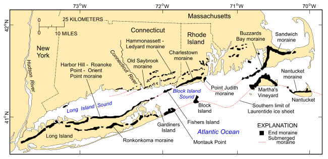
Figure 4. Map, modified from Stone and Borns (1986) and Gustavson and Boothroyd (1987), showing locations of end moraines (black polygons) in southern New England and on Long Island, New York. The Ronkonkoma-Nantucket moraine marks the Laurentide Ice Sheet's southern extent at glacial maximum about 20-24 kyBP, and the Harbor Hill-Roanoke Point-Charlestown-Buzzards Bay moraine represents the ice sheet position after a readvance around 18 kyBP (Uchupi and others, 1996). Underwater extensions of the moraines are shown as dashed lines. For a larger view of the image click here. |
||

![]() U.S. Department of the Interior |
U.S. Geological Survey
U.S. Department of the Interior |
U.S. Geological Survey
URL: http://pubsdata.usgs.gov/pubs/of/2012/1005/html/fig4.html
Page Contact Information: GS Pubs Web Contact
Page Last Modified: Tuesday, 22-Jul-2014 09:33:07 EDT

