U.S. Geological Survey Open-File Report 2012–1103
Sea-Floor Character and Geology Off the Entrance to the Connecticut River, Northeastern Long Island Sound
 |
||
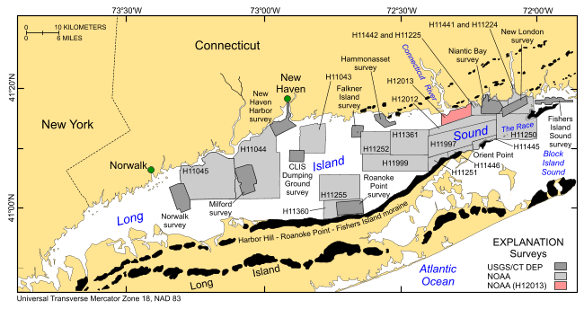
Figure 1. Index map showing the locations of the National Oceanic and Atmospheric Administration (NOAA) H12013 study area (red polygon) and the other bathymetric and backscatter surveys completed in Long Island Sound by NOAA and by the U.S. Geological Survey (USGS) and the Connecticut Department of Energy and Environmental Protection (CT DEEP). Surveys by the NOAA ships Thomas Jefferson and Rude are shown in light gray and include H11043 (Poppe and others, 2004, 2006a); H11044 (McMullen and others, 2005; Poppe and others, 2008a); H11045 (Beaulieu and others, 2005); H11255 (Poppe and others, 2006c); H11250 (Poppe and others, 2006b, 2007b); H11252 and H11361 (Poppe and others, 2007a, 2008b); H11441, H11442, H11224, and H11225 (Poppe and others, 2010a); H11445 (McMullen and others, 2010); H11251 (Poppe and others, 2010b); H11446 (McMullen and others, 2011); H11997 (Poppe and others, 2011a); H11999 (McMullen and others, 2012); and the combined contiguous datasets in eastern Long Island Sound (Poppe and others, 2011b). Sites of USGS sidescan-sonar surveys are shown in dark gray and include Norwalk (Twichell and others, 1997), Milford (Twichell and others, 1998), New Haven Harbor and New Haven Dumping Ground (Poppe and others, 2001), Roanoke Point (Poppe and others, 1999b), Falkner Island (Poppe and others, 1999a), Hammonasset (Poppe and others, 1997), Niantic Bay (Poppe and others, 1998c), New London (Lewis and others, 1998, Zajac and others, 2000, 2003), and Fishers Island Sound (Poppe and others, 1998b). |
||


